Why is your GPS or STRAVA altitude inaccurate?
Content
A recurring question or question arises regarding altitude accuracy and GPS altitude differences.
While it may seem trivial, getting an accurate height is challenging, in the horizontal plane you can easily place a tape measure, rope, geodesic chain, or accumulate the circumference of a wheel to measure distance. on the other hand, it is more difficult to position the meter 📐 in the vertical plane.
GPS heights are based on a mathematical representation of the shape of the earth, while heights on a topographic map are based on a vertical coordinate system associated with the globe.
Therefore, these are two different systems that must coincide at one point.
Altitude and vertical drop are parameters that most cyclists, mountain bikers, hikers, and climbers will want to consult with after a ride.
The instructions for obtaining the vertical profile and correct elevation difference are relatively well documented in outdoor GPS manuals (such as the Garmin GPSMap range manuals), paradoxically, this information is almost absent or cryptic in the intended GPS user manuals. for cyclists (for example, guides for the Garmin Edge GPS range).
Garmin After Sales Service hand out all the helpful advice, just like the TwoNav. For other GPS manufacturers or apps (besides Strava) this is a big gap 🕳.
How to measure the height?
Several techniques:
- Applying the famous Thales theorem in practice,
- Various triangulation techniques,
- Using an altimeter,
- Radar, Deal,
- Satellite measurements.
Barometric altimeter
It was necessary to determine the standard: the altimeter translates the atmospheric pressure of a place into an altitude. An altitude of 0 m corresponds to a pressure of 1013,25 mbar at sea level at a temperature of 15 ° Celsius.
In practice, these two conditions are rarely met at sea level, for example, when writing this article, the pressure on the coast of Normandy was 1035 mbar, and the temperature is close to 6 °, which can lead to an error at an altitude of about 500 m.
The barometric altimeter gives accurate altitude after readjustment if pressure / temperature conditions stabilize.
Adjustment is to maintain an accurate altitude for a location, and then the altimeter adjusts that altitude in response to changes in atmospheric pressure and temperature.
A drop in temperature 🌡 narrows the pressure curves and the altitude increases, and vice versa if the temperature increases.
The displayed altitude value will be sensitive to changes in ambient temperature, the user of the altimeter, who is holding or wearing it on the wrist, should be aware of the effect of local temperature changes on the displayed value (for example: watch closed / open with sleeve, relative wind due to fast or slow movements, the influence of body temperature, etc.).
To simplify the stable air mass, it is the stable weather 🌥.
When used correctly, the barometric altimeter is a reliable reference instrument for a variety of applications such as aeronautics, hiking, mountaineering ...
L'altitude GPS
GPS determines the height of a place in relation to the ideal sphere that simulates the Earth: "Ellipsoid". Since the Earth is imperfect, this height needs to be transformed to get the “geoid” height 🌍.
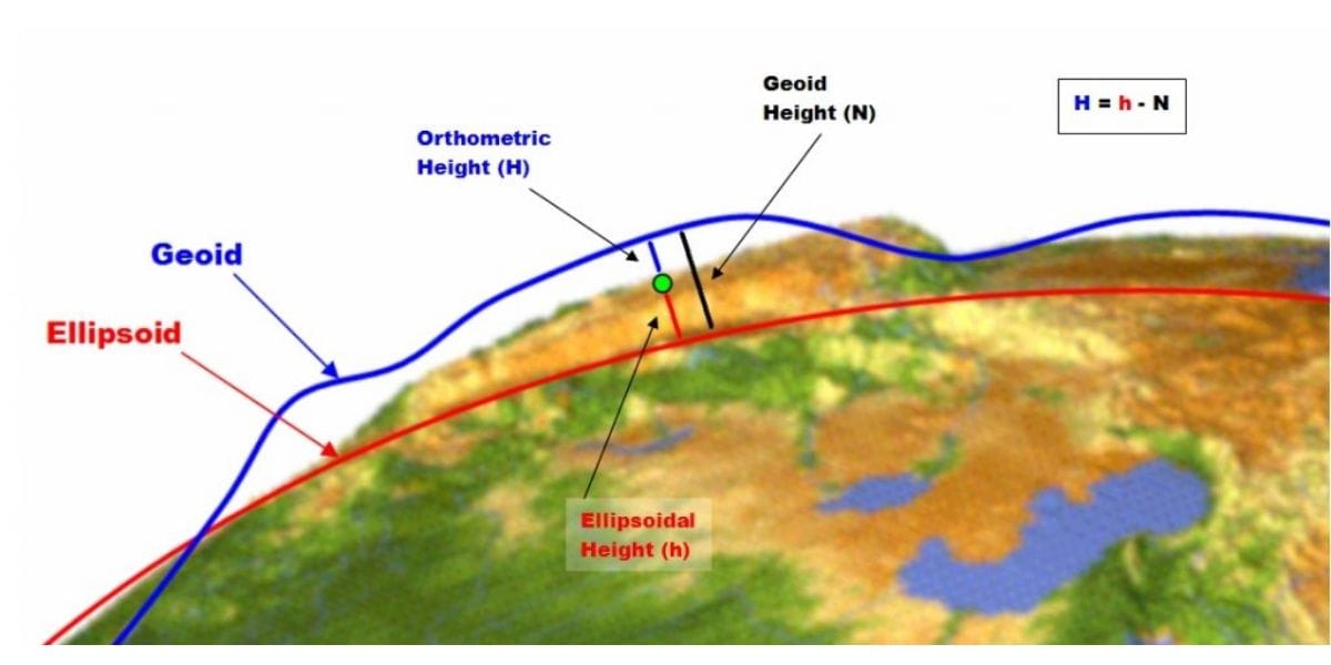
An observer who reads the height of a survey marker using GPS can see a deviation of several tens of meters, although his GPS is working correctly under ideal receiving conditions. Maybe the GPS receiver is wrong?
This difference is explained by the accuracy of modeling the ellipsoid and, in particular, the geoid model, which is complex due to the fact that the Earth's surface is not an ideal sphere, contains anomalies, is subject to human modifications and is constantly changing. (Telluric and Human).
These inaccuracies will be combined with measurement errors inherent in GPS, and will cause inaccuracies and constant variations in the altitude reported by GPS.
Satellite geometry that favors good horizontal accuracy, that is, the low position of the satellites on the horizon, prevents accurate altitude acquisition. The order of magnitude of the vertical precision is 1,5 times the horizontal precision.
Most GPS chipset manufacturers integrate the mathematical model into their software. which approaches the geodetic model of the earth and provides the height specified in this model.
This means that if you are walking on the sea it is not unusual to see negative or positive altitude, because the geodetic model of the earth is imperfect, and to this shortcoming must be added the error inherent in GPS. The combination of these errors can cause an elevation deviation of more than 50 meters at certain locations 😐.
The geoid models have been refined, in particular, the altimetry obtained as a result of GNNS positioning will remain inaccurate for several years.
Digital Terrain Model “DTM”
A DTM is a digital file composed of grids, each grid (square elementary surface) provides a height value for the surface of that grid. An idea of the current grid size of the world elevation model is 30 m x 90 m. Knowing the position of a point on the surface of the earth (longitude, latitude), it is easy to get the height of the place by reading the DTM file (or DTM, Digital Terrain Model in English).
The main disadvantage of a DEM is its reliability (anomalies, holes) and file accuracy; Examples:
- The ASTER DEM is available with a step (grid or pixel) of 30 m, horizontal accuracy of 30 m and an altimeter of 20 m.
- The MNT SRTM is available for 90 m spacing (grid or pixel), approximately 16 m altimeter and 60 m planimetric accuracy.
- The Sonny DEM model (Europe) is available in 1°x1° increments, i.e. with a cell size on the order of 25 x 30 m depending on latitude. The vendor has compiled the most accurate data sources, this DEM is relatively accurate and can be used “easily” for TwoNav and Garmin GPS via the free OpenmtbMap mapping.
- IGN DEM 5m x 5m is available free of charge (from January 2021) in 1m x 1m or 5m x 5m steps with 1m vertical resolution. Access to this DEM is explained in this guide.
Don't confuse the resolution (or the accuracy of the data in the file) with the actual accuracy of that data. Readings (measurements) can be obtained from instruments that do not allow observing the surface of the globe to the nearest meter.
IGN DEM, available free of charge 🙏 from January 2021, is a patchwork of readings (measurements) obtained with various instruments. Areas scanned for recent research (eg flood risk) were scanned at 1 m resolution, elsewhere the accuracy may be very far from this value. However, in the file, the data has been interpolated to fill the fields in 5x5m or 1x1m increments. IGN has launched a high-resolution polling campaign with the goal of fully covering France by 2026, and on that day, IGN DEM will be accurate and free at 1x1x1m intervals. ...
The DEM shows the elevation of the ground: the height of the infrastructure (buildings, bridges, hedges, etc.) is not taken into account. In the forest, this is the height of the earth at the foot of the trees, the surface of the water is the surface of the coast for all reservoirs larger than one hectare.
All points in a cell have the same height, so at the edge of the cliff, due to the uncertainty of the file location, summed up with the uncertainty of the location, the extracted height may be the same as the neighboring cell.
The GPS positioning accuracy under ideal reception conditions is in the order of 4,5 m at 90%. This performance is seen with the most recent GPS receivers (GPS + Glonass + Galileo). Therefore, the accuracy is 90 times out of 100 between 0 and 5 m (clear sky, excluding masks, excluding canyons, etc.) of the real location. using a DEM with a 1 x 1 m cell is counterproductive.because the chances of being on the correct grid will be rare. This choice will overwhelm the processor with no real added value!

To get a DEM that can be used in:
- TwoNav GPS: CDEM на 5 m (RGEALTI).
Garmin GPS: Sonny Database
Learn how to create your own DEM for TwoNav GPS. Level curves can be extracted using Qgis software.
Determine the altitude using GPS
One solution might be to load the DEM file into your GPS navigator, but the altitude will only be reliable if the grids are reduced in size and if the file is accurate enough (horizontally and vertically).
To get a good idea of the quality of the DEM, it is enough to visualize, for example, the relief of a lake or build a path that crosses the lake and observe the elevations in a 2D section.

Image: LAND software, view of Lake Gerardmer in 3D magnification x XNUMX with correct DEM. The projection of meshes onto the terrain shows the current DEM limit.

Image: LAND program, view of the Gérardmer lake “BOG” in 2D with the correct DTM.
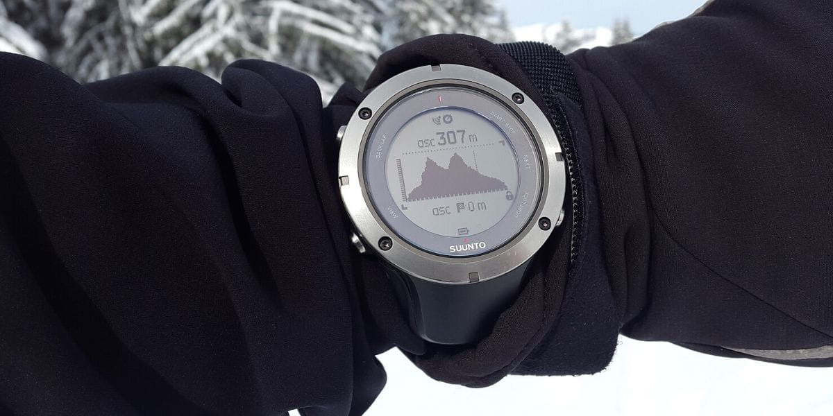
All modern “good quality” GPS devices have a compass and a digital barometric sensor, hence a barometric altimeter; Using this sensor allows you to get an accurate altitude provided you set the altitude at a known point (Garmin recommendation).
The altitude imprecision provided by GPS since the advent of GPS has prompted the development of hybridization algorithms for aeronautics that use barometer altitude and GPS altitude to provide accurate geographic position. height. It is a reliable altitude solution and the preferred choice of GPS manufacturers, optimized for outdoor TwoNav practice. and Garmin.
At Garmin, the GPS offering is introduced according to the user profile (outdoor, cycling, mountain biking, etc.), so it is important to refer to the user manuals and after-sales service.
The optimal solution is to set your GPS to the option:
- Altitude = Barometer + GPS, if GPS allows,
- Altitude = Barometer + DTM (MNT) if GPS allows.
In all cases, for a GPS equipped with a barometer, manually set the barometer to its minimum altitude at the starting point. In the mountains ⛰ on long runs, the setting will need to be redone, especially in the event of fluctuations in temperature and weather.
Some Garmin GPS-optimized cycling devices automatically reset the barometric altitude at known altitude waypoints, which is an especially smart solution for mountain biking. However, the user must inform, for example, before leaving the height of the passes and the bottom of the valley; on the way back, the height difference will be accurate 👍.
In Barometer + (GPS or DTM) mode, the manufacturer includes an automatic barometer adjustment algorithm based on the principle that the rise seen by the barometer, GPS or DEM must be consistent: this principle offers great flexibility to the user and is well suited for outdoor activities.
However, the user should be aware of the limitations:
- The GPS is based on the geoid, so if the user moves through artificial terrain (for example, to slag dumps), the corrections will be distorted,
- The DEM shows the path on the ground, if the user borrows a significant part of the human infrastructure (viaduct, bridge, pedestrian bridges, tunnels, etc.), the adjustments will be offset.
Therefore, the optimal procedure for obtaining an accurate elevation increase is as follows:
1️⃣ Adjust the barometric sensor at the beginning. Without this setting, the heights will be converted (shifted), the difference in level will be correct if the drift due to weather is small (short route outside the mountains). For Garmin family GPS users, “gpx” heights are used by Garmin and Strava for the community, so it is preferable to enter the correct elevation profile into the database.
2️⃣ To reduce the drift (error in altitude and altitude) due to weather conditions on long journeys (> 1 hour) and in the mountains:
- Focus on choice Barometer + GPS, outside areas with artificial relief (dump areas, artificial hills, etc.),
- Focus on choice Barometer + DTM (MNT)if you have installed an IGN DTM (5 x 5 m grid) or Sonny DTM (France or Europe) outside of a route that uses a significant portion of the infrastructure (pedestrian bridges, overpasses, etc.).
Developing a height difference
The altitude problem described in the previous lines most often manifests itself after observing that the difference in altitude between the two practitioners is different or varies depending on whether it is read on GPS or in an application like STRAVA (see STRAVA help) for example.
First of all, you need to tune your GPS to provide the most reliable altitude.
It is quite simple to get the difference in levels by reading the map, often the practitioner is limited to determining the difference between the points of extreme dimensions, although, to be precise, it is necessary to count the positive contour lines to get the sum.
There are no horizontal lines in the digital file, the GPS software, track plotting application, or analysis software is configured to “accumulate steps or elevation increments”.
Often "no accumulation" can be configured:
- in TwoNav the setting options are common to all GPS
- at Gamin you should consult the user manual and after-sales service (each model has its own characteristics according to the typical user profile)
- the OpenTraveller app has an option that suggests adjusting the sensitivity threshold for determining the difference in height.
Everyone has their own solution 💡.
Websites or software for online analysis strive to replace height from "gpx" files with their own height data.
Example: STRAVA has created a "native" altimetry file created using elevations derived from tracks derived from GPS known to STRAVA and is equipped with a barometric sensor. The adopted solution assumes that the GPS is known to STRAVA, so at the moment it is mainly obtained from the GARMIN range, and the reliability of the file assumes that each user has taken care of manual altitude reset.
As for the practical implications, the problem arises especially during group walks, because each participant 🚵 may notice that their elevation difference is different from the level of other participants, depending on their type of GPS, or it is a curious user who does not understand why the difference is GPS altitude, analysis software or STRAVA is different.

In the perfectly sanitized STRAVA world, all members of the GPS GARMIN user group should in principle see the same altitude on their GPS and on their STRAVA. It is logical that the difference can only be explained by the height adjustment, however nothing confirms the reported height difference is correct.
It is logical that a member of this user group who has a GPS not known to STRAVA should see the same altitude difference on STRAVA as his assistants, although the level difference displayed by his GPS is different. He can blame his equipment, which nevertheless works correctly.
The closest to true value of the difference in height is still obtained in FRANCE or BELGIUM when reading the IGN card., the commissioning of a more advanced geoid will gradually move the landmark towards GNSS
GNSS: Geolocation and Navigation Using a Satellite System: Determining the position and speed of a point on the surface or in the immediate vicinity of the Earth by processing radio signals from several artificial satellites received at that point.
If you need to rely on software or an application to get the elevation difference, you must adjust this software to adjust the accumulation step value according to the contour lines of the IGN map of the site, that is, 5 or 10 m. A small step will turn into a drop all small jumps or transitions to bumps, and vice versa, a too high step will erase the rise of small hills.
After applying these recommendations, the author's experiment shows that the altitude values obtained using GPS or analysis software equipped with a reliable DEM remain within the "correct" range, assuming that the IGN map also has its own uncertaintiescompared to the estimate obtained with the IGN card 1 / 25.
On the other hand, the value published by STRAVA is usually overstated. The method used by STRAVA, based on the "feedback" from users, theoretically makes it possible to predict a rapid convergence to values that are very close to the truth, which, depending on the number of visitors, should already take place in BikePark or very busy tracks!
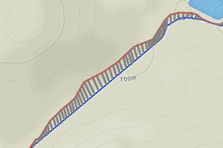
To illustrate this point concretely, here is an analysis of a track, taken at random, on a 20 km long hilly road. The "barometric" GPS altitude was set before departure, it provides the "Barometric + GPS" altitude, the DTM is a reliable DTM that has been redesigned to be accurate. We are outside the area where STRAVA could have a reliable elevation profile.
This is an illustration of a track where the difference between IGN and GPS is the largest and the difference between IGN and STRAVA is the smallest. the distance between GPS and STRAVA is 80m, and the true "IGN" is between them.
| Heights | ||||||
| The start | Arrival | Max | min | height | Deviation / IGN | |
| GPS (Barrier + GPS) | 122 | 124 | 150 | 98 | 198 | -30 |
| Height adjustment on DTM | 122 | 122 | 150 | 98 | 198 | -30 |
| FOOD | 280 | +51 | ||||
| IGN cards | 122 | 122 | 148 | 99 | 228,5 | 0 |