10 Best Scenic Spots in Virginia
Content
- No. 10 - Breaks Interstate Park
- No. 9 – Lysburg loop
- No. 8 - Coastal Virginia - Hampton Roads.
- No. 7 - Excursion to country shops and rural post offices
- #6 – Nelson Scenic Loop
- No. 5 - Bridge-tunnel across the Chesapeake Bay.
- No. 4 - Colonial National Historic Boulevard.
- No. 3 - George Washington Memorial Boulevard.
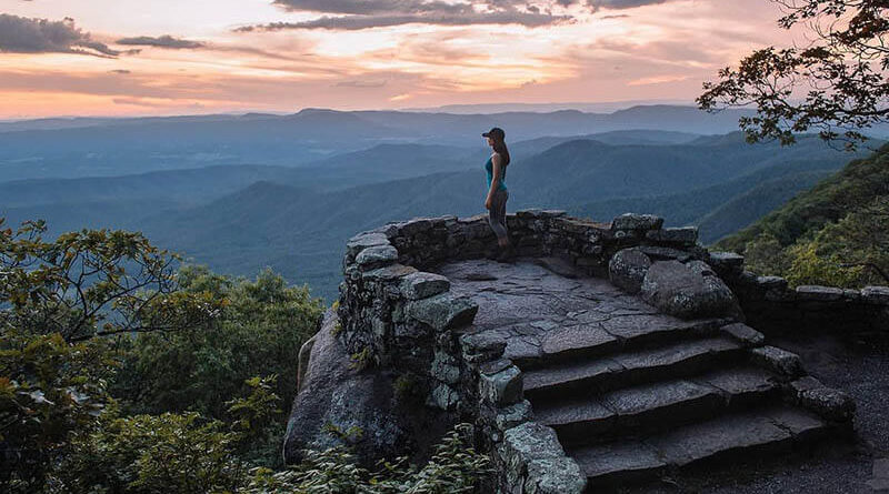
- No. 2 - Blue Ridge Parkway.
- No. 1 - Skyline Drive
Virginia is a state known for its natural beauty and is home to several national and state parks. Scenic roads can be found at almost every turn. However, there is more to this region than just its stately mountains, regal valleys and raging rivers. The area is deeply rooted in American history, from its Native American roots to the first European settlers and some of today's most important government operations. With so much to see and do, it can be difficult for visitors to choose just one way to see the state. That's why we've put together this list of scenic spots to help kickstart your Virginia trip:
No. 10 - Breaks Interstate Park
Start Location: Rosedale, Virginia
Final location: Sand Lick, Virginia
Length: Mile 40
Best driving season: Spring, summer and autumn
View this drive on Google Maps
With the natural splendor of Jefferson State Park and Breaks Interstate Park along much of this route, there is no shortage of scenic spots to discover. In Honaker, the Redbud Capital of the World, visit the charming city center full of historic buildings and specialty shops. Near the state line at Breaks Interstate Park, look into the 1,600-foot deep canyon of the Russell Fork River, where white water rafting is a popular activity.
No. 9 – Lysburg loop
Start Location: Leesburg, Virginia
Final location: Leesburg, Virginia
Length: Mile 41
Best driving season: All
View this drive on Google Maps
This scenic drive on the outskirts of Washington DC leaves metropolitan life behind and offers a surprisingly beautiful way to spend a morning or afternoon. The landscape, with rolling hills and forests prized by local fox hunters, is beautiful. The restored mansion and grounds at Oatlands are also worth a look to see how the privileged once lived in the area.
No. 8 - Coastal Virginia - Hampton Roads.
Start Location: Newport News, Virginia.
Final location: Hampton, Virginia
Length: Mile 10
Best driving season: All
View this drive on Google Maps
Overlooking the nearby bay, this road is full of stops that military history buffs love along the way. Travelers can spend a full day exploring places like the Virginia Military Museum, the Hampton Roads Naval Museum, and the General Douglas MacArthur Memorial. For those less interested in military affairs, stop at Sandy Bottom Nature Park to enjoy the trails.
No. 7 - Excursion to country shops and rural post offices
Start Location: Gloucester, Virginia
Final location: Gloucester, Virginia
Length: Mile 3
Best driving season: All
View this drive on Google Maps
This three-mile trip may not take long if you drive straight ahead, but can easily take an hour or two with stops to explore. There are XNUMX village shops and village post offices along the way, some of which are still in operation. These sites were once community hubs, and those who visit them can feel transported to another place and time.
#6 – Nelson Scenic Loop
Start Location: Wintergreen, Virginia
Final location: Wintergreen, Virginia
Length: Mile 42
Best driving season: All
View this drive on Google Maps
Travelers enjoy mountain views and fertile farmland on this tour of Nelson County. Hike the trails around Crab Tree Falls, which has one of the highest falls east of the Mississippi River. In the Sea Bass Valley, stop at one of several local wineries for an educational tour and some sampling.
No. 5 - Bridge-tunnel across the Chesapeake Bay.
Start Location: Virginia Beach, Virginia.
Final location: Cape Charles, Virginia
Length: Mile 19
Best driving season: All
View this drive on Google Maps
This convenient over-the-ocean route from Virginia Beach to the state's east coast is relatively short, but memorable. Stop at Seagull Island to watch ships pass by and take photos of the Atlantic Ocean and the Chesapeake Bay. The salt marshes and dunes on Fisherman's Island are also worth seeing, with their abundant wildlife and beautiful scenery.
No. 4 - Colonial National Historic Boulevard.
Start Location: Jamestown, Virginia
Final location: Yorktown, Virginia
Length: Mile 25
Best driving season: All
View this drive on Google Maps
While the trip isn't long, it's jam-packed with things to see and do. See artifacts and exhibits relating to the country's birth at the Jamestown Settlement. A stop at Colonial Williamsburg, the world's largest living exhibition, is an absolute must to step back in time and experience first hand what it was like to live there in the 1700s.
No. 3 - George Washington Memorial Boulevard.
Start Location: Mount Vernon, Virginia
Final location: Washington
Length: Mile 16
Best driving season: All
View this drive on Google Maps
Follow the Potomac River and brush up on your knowledge of American history as you travel from George Washington's home in Mount Vernon to the nation's capital, Washington, DC. Mount Vernon Estate and Gardens is full of learning and photography opportunities. Don't miss the Jones Point Lighthouse, one of the few remaining lighthouses of its kind with fishing and picnic spots nearby.
No. 2 - Blue Ridge Parkway.
Start Location: Rockford Gap, Virginia
Final location: Maggie Valley, North Carolina
Length: Mile 392
Best driving season: Spring, summer and autumn
View this drive on Google Maps
This trail, winding along the Appalachians, connects Virginia's Shenandoah National Park with North Carolina's Great Smoky Mountains National Park and is renowned for its spectacular views. With over 200 views, there are plenty of photo opportunities in the region, and there's always a reason to stop and recharge after a long drive. Stop at Mabry Mill to learn more about the life of the early settlers from the park's interpreters, who demonstrate skills such as basket weaving and thread spinning on site.
No. 1 - Skyline Drive
Start LocationLocation: Front Royal, Virginia.
Final location: Waynesboro, Virginia
Length: Mile 111
Best driving season: All
View this drive on Google Maps
Running along the crest of the Blue Ridge Mountains and through Shenandoah National Park as an extension of Blue Ridge Parkway, Skyline Drive is the most famous scenic drive in the state for good reason. On one side of the route you will see hilly terrain, and on the other, agricultural valleys. While impressive photos can be taken at almost any stop along the way, don't miss the Pinnacles Overlook, which showcases one billion-year-old geological formations.