Automatic Mountain Bike Routing: Why Not Ideal?
Content
Some software, but most of all, many applications (applications) allow you to quickly, in a few clicks (Router, Routing, Router), route a bike, gravel, MTB route or even a walking route.
However, the result can go from bluffing to a lot of frustration, seeing a spaghetti fight that may seem “crazy”, but should you blame the APPLI and throw it away?
It's natural to blame this app, but it's only partly to blame for this frustration, regardless of the app, because the main reason has to do with the abundance of data associated with the map.
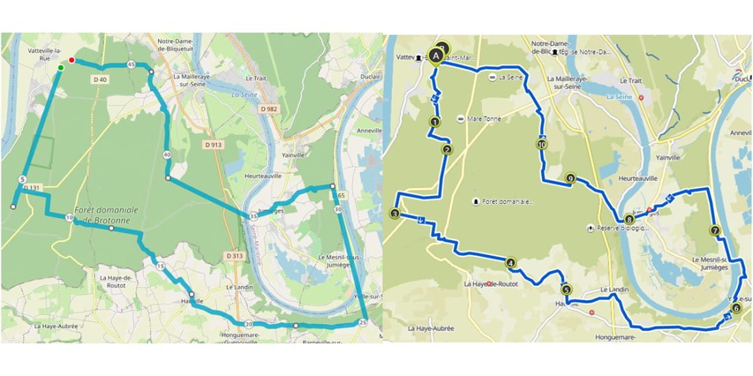 Routing in Broughton Forest by two different applications, one of which on the left fails at least three times, likely due to low MTB data level on the OSM map.
The maps available and used by these apps (and software) are either Open Street Map, https://www.openstreetmap.fr/, available at zero cost, TomTom or Google, which "starts" in "No tar".
The illustration of this subject is based on the Open Street Map (OSM), which is widely used by application developers as it is free.
Specifically, OSM, like its "competitors", is a database containing a list of "objects". To draw a map, the program will extract from this database and for each object the typical characteristics of the desired map. Then it will generate a "vector" map, that is, a sequence of lines and points, the map drawing remains clear, regardless of the zoom level.
For a mountain bike map, an algorithm that looks for the characteristics that define a mountain bike map, allowing each application to present a "branded" mountain bike map, most notably the topographic map. From Garmin.
OSM map data comes primarily from voluntary contributions (crowdsourcing). OSM, based on this principle, for several years, some "institutions" that decided to move away from the major American cartographic players, also participated in this mode. These institutions prefer OSM as a mapping tool in their territory, therefore the contribution is under professional supervision (for example: Lyon, Ile-de-France, etc.). We can clearly see that in these areas the map is broader and more structured. On a national or regional scale, this leads to very large discrepancies in the richness and nature of the data included in this map.
 OSM MTB map Garmin type look, left Vosges massif (north of Belfort), right Bretonne forest (south of Rouen) https://www.calculitineraires.fr/.
Our comments, focused on the relevance of bike, mountain bike and gravel routes, deliberately do not mention the impressive amount of data displayed in OSM.
The image below is a global scale European view of cycling lanes known to OSM, this image shows the density of the lanes that will be selected primarily by the algorithms of applications using the OSM map to plot the cycling route. ...

Either there are more bike paths “outside France” or the OSM map is poorly informed in France ... Answer: Both my captains!
Zooming in on an area covering parts of the Greater East and Germany, the image covers areas of similar population density. On the German side, the density of cycle lanes mostly matches the built-up density, the map appears to be uniform. As for France, the observation is clear: it is completely incomparable, the map around Charmès is better informed than Nancy or Colmar, there is still a lot of work to be done to get a map suitable for routing.
Since OSM is based on the principle of voluntary contributions, it is up to cyclists to provide information and update the map.

OSM (like its competitors) is a cartographic database from which layers can be extracted according to the criteria of interest, the author asks UMAP (a simple viewer) to display the OUTER layer, that is, the density of paths and paths in two similar zones in terms of "real" suggestion in saved versions.
We can clearly see that routing will be much easier, more relevant given that the offer is more extensive on the map (for the router) in the Black Forest than in the Vosges, although in the field the density and quality of the offers in trails, trails, in the Vosges is exceptional. It is appreciated in other tools, but not in OSM; as a result, routing (GPX file from applications) in this region is poor.
 Black Forest east of Colmar
 Vosges west of Colmar.
Let's take a look at the map that the route planner sees, for illustration the author chose the Komoot app https://www.komoot.fr/ because of its "sexy" graphical aspect. Demonstration can also be performed using another application. The graphic aspect allows you to correctly highlight the main problem. In the Black Forest (paths in green), the image below shows all the solutions that contribute to “cycling”, since the algorithm has several solutions, it can suggest an appropriate route according to predefined criteria.

Below, the Vosges side: the algorithm will have to choose from roads without other criteria, because routes suitable for cycling are not highlighted on the map. Depending on the application, the user will be more or less satisfied.

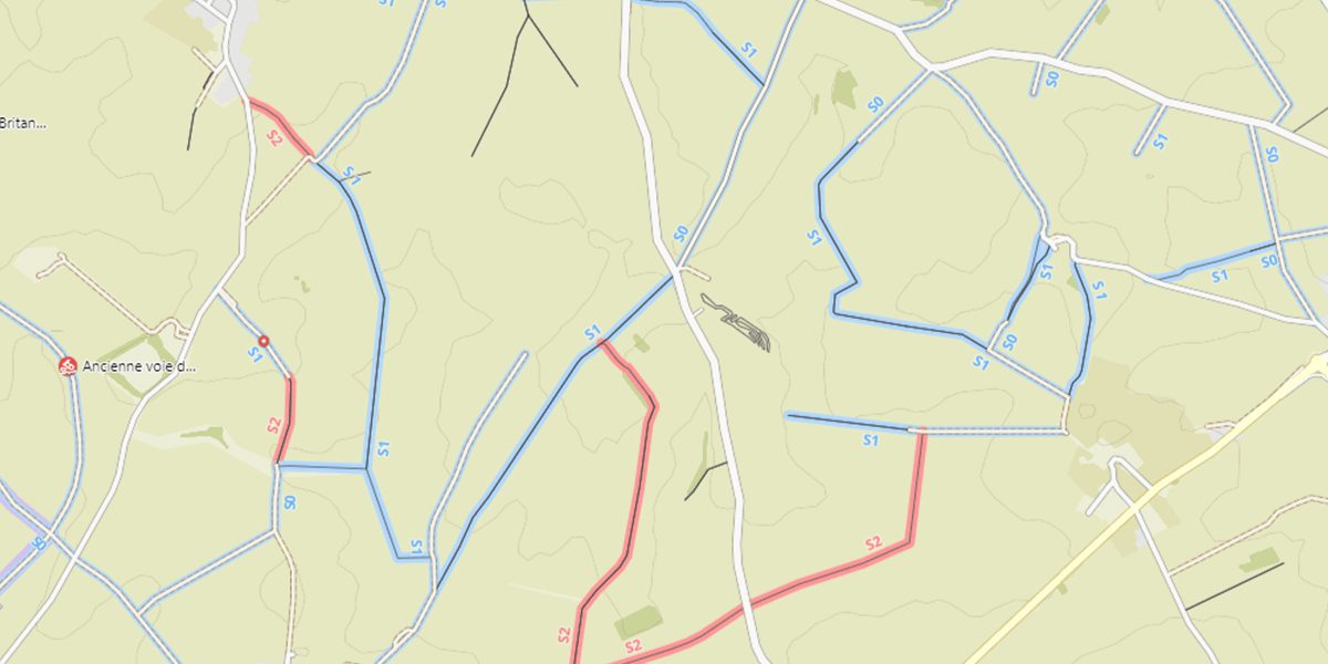
In terms of mountain biking, let's compare the sector taken at random in the Black Forest and the Spot, famous for mountain biking in France, in particular for hosting the XC and DH international competitions: La Bresse in the Vosges.
In the Black Forest (below), the algorithm will be able to choose between different difficulty levels (S0, S1, S2 ...), avoid or keep difficult climbs or descents. It is very likely that the suggested route (GPX) matches or is very close to the options you have identified.

Below, in the Vosges, the color purple predominates. The default algorithm will choose the path that will accept the paths highlighted in purple, the user will have to help him build the correct GPX, because the MTB path estimate exists but is minimal.

Below is an example of an area where the OSM MTB map is optimal as all trails and trails are classified for cycling, mountain biking, hiking (illustration of a map view for mountain biking). The route suggested by the powerful application is as follows: On the one hand, it is created very quickly and very up-to-date, manual assistance is minimized.
Each application uses its own algorithms; they will not offer strictly the same routes, however in the state "in France" the difference between the expected route and the route that will leave is mainly due to the level of information on the map.
Online apps, at least the most efficient ones, update their maps regularly. They will always be more up-to-date than software that usually uses much older maps. An update made to OSM counts graphically in the next hour for the most responsive apps; In terms of routing, the latency ranges from one to several weeks.
What's really hidden under the map
Let's see what information is hidden behind the card. Those that will feed the routing algorithm.
The image below shows data for a cycling route in Mormal Forest.

OSM is a collaborative project, the employee is not required to fill in all the fields, it should be assumed that with time and goodwill the menu will become richer and better, this is the principle of crowdsourcing, like in Wikipedia.
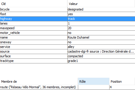
- Bicycle: Essential for cycling, this is a bike path that is neither a cycle path nor exclusively a bicycle path,
- On foot: accepts pedestrians, tourists
- Highway: type of road, belongs to the category of tracks,
- Surface / Track Type: In this example, the ground is solid without gravel, this criterion allows you to optimize the route, this is where the concept of gravel appears ...
- Member ... In this figure, the route is part of an officially registered route, it can be imported directly by some applications.
Below map rendering (OSM Cyclo) comparison between U Map (simple viewer) and Komoot (application) shows in this example that the application does not degrade the data on the map, the router may prefer paths suitable for cyclists in this forest.
 OSM Cycles of Mormal Forest rendered Umap
 OSM Cycles of the Forest of Mormal, rendered by Komuth
The richness of the data presented and its accuracy, combined with the intelligence of the algorithm implemented by the application, ensures that the route obtained as a result of routing will be more or less optimized.
Illustration for mountain biking or hiking
What is important
The path is the path in the sense of a mountain trail, along which it is impossible to overtake on a mountain bike, and where to park for crossing paths (on foot or by mountain bike), it is a generally accepted international convention... Whenever it is possible to stand together, on foot or on a mountain bike, the term “track” should be used.
The basic important data is limited by the type (track / path) and the type of track (classification of a 1st level track, on which you can easily cycle on a bike with an impassable level 5).
This is optional, but very useful.
All the data will allow the application's algorithm to suggest a route adapted to practice, which becomes important when summarizing the use of cycling, mountain biking and mountain biking.
The example below shows part of a challenging single (red) mountain bike (grade 3, scale 2, slope 20 & # 0006). This is a path that should be avoided by some or preferred to others. If the algorithm has this data, it can provide relevant and useful data about physical and technical obligations..

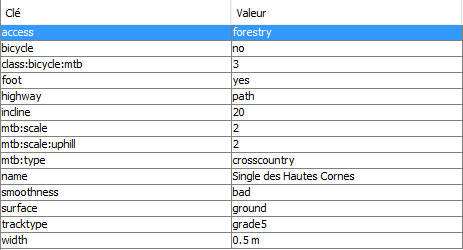
Advice. Passing a trace.gpx file imported from the Internet through a routing application allows, on the one hand, to clear this "gardening" trail, if any, and, above all, to identify paths that could cause problems in the field. ...
Importance of data
Below is a graphical comparison of a mountain bike map viewed by two apps in two geographic areas populated differently. On the left is an OSM VTT view of the Vosges north of Belfort, on the right is a mountain bike view of the Broughton forest south of Rouen. On the left is the map that two different apps see, they have the data associated with the map to cut a beautiful mountain bike route, on the right, nothing will allow these two apps to prefer one route over the other, the route will be “soft”.