Understand mountain bike trail classification in Openstreetmap
Content
The OSM Open Steet Map, which has over 5000 members per day, allows editing of OSM maps designed for mountain biking and particularly efficient mountain biking trails.
This contribution follows the same principle as route sharing (“gpx” split): publish and share routes, increase traffic and perpetuate their existence; it complements the broadcast of your "gpx" on UtagawaVTT.
OSM maps are used by many mountain biking or hiking sites, either as a map or for route routing, such as OpenTraveller which offers various background maps from OSM, most GPS manufacturers offer OSM mapping for their GPS (Garmin, TwoNav , Wahoo, etc….), Another example of MOBAC that allows you to create maps for tablets, GPS… (MAPS AND GPS - HOW TO CHOOSE?)
Each of us can contribute to this collective momentum by adding or modifying the paths or paths we take regularly to engrave them in stone.
Two tools available to everyone to enrich this cartographic database, OSM editor and JOSM. In addition to the step of getting started with these two tools, the beginner should become familiar with the concepts of trail classification.Despite the abundance of information on the internet, the beginner cannot quickly figure out how to characterize a mountain bike trail to be correctly displayed on the map.
The purpose of the following lines is to present classification criteria to show that it is enough to simply enter two parameters for the OSM to highlight routes suitable for mountain biking, the other parameters enrich the performance but are not essential. .
The Internet also puts the participant in front of different classification systems, more or less similar but different. The two main classification systems are "IMBA" and "STS", which more or less have different variations.
Open Street Map allows each route to be assigned an STS classification and / or an IMBA classification.
The best place to start is to start contributing with the OSM editor and wait until you are fluent in OSM to use JOSM, which is more complex but offers many more features.
SINGLE SCALE (STS)
The name "single trail" suggests that a mountain bike trail is a trail that can't be walked by more than one person. A typical single track illustration is a narrow mountain path that is also used by trailers and hikers. The best way to get ahead on the "single track" is to use a mountain bike that is equipped with at least one suspension fork and, at best, full suspension.
The trail classification system is for mountain bikers, the UIAA scale is for climbers, and the SAC Alpine scale is for climbers.
The grading scale was developed in order to provide information on the difficulty of progress, that is, a criterion for determining "cyclicality".
This classification is useful for route selection, for predicting cyclic conditions, for assessing required piloting skills.
Thus, this classification allows:
- Individually to make the most of a circuit adapted to their abilities. *
- For a club, association, service provider for the development of a route or scheme designed for the desired level of practice, as part of a hike, competition, service for a group, The mountain bike classification scale is an important benchmark that deserves standardization, but is recognized by official associations.
Characteristics of difficulty levels
The classification scale, divided into six levels (from S0 to S5), characterizes the level of difficulty, it is based on the technical problem that one has to face when driving on the road.
To achieve a universal and consistent classification, ideal conditions are always assumed, i.e. driving on a clearly visible road and dry land.
The difficulty level caused by weather, speed and lighting conditions cannot be taken into account due to the great variability they cause.
S0 - very simple
This is the simplest type of track, which is characterized by:
- Slight to moderate slope,
- Non-slippery ground and gentle turns,
- There are no special requirements for piloting technique.
S1 is easy
- This is the type of track that you might have to look forward to.
- There may be small obstructions such as roots or stones,
- The ground and turns are partly unstable, and sometimes narrower,
- No tight turns
- The maximum slope remains below 40%.
S2 - medium
The difficulty level of the trail increases.
- Big stones and roots are expected,
- Rarely is there hard soil under wheels, bumps or bearings.
- Tight turns
- The maximum slope can be up to 70%.
S3 - difficult
We refer to this category as paths with complex transitions.
- Large stones or long roots
- Tight turns
- Steep slopes
- You often have to wait for the clutch
- Regular inclines up to 70%.
S4 - very difficult
In this category, the track is difficult and difficult.
- Long and difficult journeys with roots
- Passages with large stones
- Cluttered passages
- Sharp turns and steep climbs require special riding skills.
S5 - extremely difficult
This is the most difficult level, which is characterized by very difficult terrain.
- Soil with poor adhesion, blocked by stones or rubble,
- Tight and tight turns
- Tall obstacles like fallen trees
- Steep slopes
- Small braking distance,
- Mountain biking technique is put to the test.
Representation of difficulty levels
Since there is some consensus regarding the cyclic characterization of a VTT path or path, unfortunately, it can only be noted that the graphics or visual identity of these levels are interpreted differently depending on the card publisher.
Open street map
The Open Street Map cartographic database allows you to characterize routes and trails suitable for mountain biking. This characteristic is materialized by the notion of a key (tag/attribute), it is used for graphical representation of paths and trails on maps from OSM, as well as using automatic routing tools to build and select a path to obtain a “gpx” file of a track (OpenTraveller).
OSM gives the cartographer the opportunity to enter several keys that will characterize trails and trails suitable for mountain biking.
The relatively “long” list of these keys can scare off the novice cartographer.
The table below lists the main keys to highlight two keys necessary and sufficient for the classification required for mountain biking... These two keys can be supplemented with a climb or descent characteristic.
Other extra keys allow you to give the single a name, assign a note, etc. Secondly, when you are "fluent" in OSM and JOSM, you probably want to enrich your favorite "single" by naming or rating it.
Link to OSM VTT France
| Key | value | essential | |
|---|---|---|---|
| highway = | Path Track | X | Way or way |
| ft = | - | So accessible to pedestrians | |
| bike = | - | If available for bicycles | |
| width = | - | Track width | |
| surface = | - | Type of soil | |
| smoothness = | - | surface Conditions | |
| trail_visibility = | - | Path visibility | |
| mtb: scale = | 0 6 to | X | Natural path or path |
| mtb:scale:imba = | 0 4 to | X | Bike park track |
| mtb: scale: uphill = | 0 5 to | ? | The difficulty of ascent and descent must be indicated. |
| slope = | <x%, <x% ou up, down | ? | The difficulty of ascent and descent must be indicated. |
mtb: ladder
This is the key that defines the classification that will be used to characterize the difficulty of "natural" trails suitable for mountain biking.
Since the difficulty of downhill is different from the difficulty of climbing in mountain biking, a key must be executed to “climb” or “descend”.
Characteristics of specific or very difficult border crossing points
To highlight a place on a path that presents a particular difficulty, it can be "highlighted" by placing a knot where the difficulty is. Placing a point on a different scale than the trail outside of this trail indicates a more difficult point to bypass.
| value | Description | ||
|---|---|---|---|
| OSM | IMBALANCE | ||
| 0 | - | Gravel or compacted soil without much difficulty. This is a forest or country trail, no bumps, no stones and no roots. The turns are wide and the slope is light to moderate. No special piloting skills are required. | S0 |
| 1 | - | Small obstructions such as roots and small stones and erosion can increase the difficulty. The earth can be loose in places. There can be tight turns without a hairpin. Driving requires attention, no special skills. All obstacles are passable by mountain bike. Surface: possible loose surface, small roots and stones, Obstacles: small obstacles, bumps, embankments, ditches, ravines due to erosion damage, Slope slope: | S1 |
| 2 | - | Obstacles such as large boulders or rocks, or often loose ground. There are quite wide hairpin turns. Surface: generally loose surface, larger roots and stones, Obstacles: simple irregularities and ramps, Slope slope: | S2 |
| 3 | - | Lots of passages with large obstacles such as rocks and large roots. Numerous studs and gentle curves. You can walk on slippery surfaces and embankments. The ground can be very slippery. Constant concentration and very good piloting are required. Surface: many large roots, or stones, or slippery earth, or scattered talus. Obstacles: Important. Slope:> 70% Elbows: Narrow hairpins. | S3 |
| 4 | - | Very steep and difficult, the passages are lined with large stones and roots. Often scattered debris or debris. Very steep passes with very sharp hairpin turns and steep climbs that could cause the handle to touch the ground. Piloting experience is required, for example, steering the rear wheel through the studs. Surface: many large roots, stones or slippery soil, scattered debris. Obstacles: Difficult to overcome. Slope:> 70% Elbows: Studs. | S4 |
| 5 | - | Very steep and difficult, with large fields of rocks or debris and landslides. A mountain bike must be worn for oncoming climbs. Only short transitions allow acceleration and deceleration. Fallen trees can make very steep transitions even more difficult. Very few mountain bikers can ride at this level. Surface: rocks or slippery soil, debris / uneven path that looks more like an alpine hiking trail (> T4). Obstacles: Combinations of difficult transitions. Slope gradient:> 70%. Elbows: Dangerous in stiletto heels with obstacles. | S5 |
| 6 | - | A value assigned to trails that are generally not ATV-friendly. Only the best trial specialists will try to browse these places. The tilt is often> 45 °. This is an alpine hiking trail (T5 or T6). It is a bare rock with no visible marks on the ground. Irregularities, steep slopes, embankments over 2 m or rocks. | - |
mtb: scale: uphill
This is the key to fill in if the cartographer wants to clarify the difficulty of the ascent or descent.
In this case, you need to verify the direction of the path and use the slope key so that the routing software can account for the difficulty of navigating in the right direction.
| value | Description | awning | Obstacles | |
|---|---|---|---|---|
| Average | maximum | |||
| 0 | Gravel or hardened earth, good adhesion, available to everyone. You can climb and descend by 4x4 SUV or ATV. | <80% | <80% | |
| 1 | Gravel or hardened ground, good traction, no slippage, even when dancing or accelerating. Steep forest trail, easy walking trail. | <80% | Isolated obstacles that can be avoided | |
| 2 | Stable ground, unpaved, partially washed out, requires regular pedaling and good balance. With good technique and good physical condition, this is achievable. | <80% | <80% | Rocks, roots, or protruding rocks |
| 3 | Variable surface conditions, slight irregularities, or steep, rocky, earthy or oily surfaces. Very good balance and regular pedaling is required. Good driving skills so as not to drive the ATV uphill. | <80% | <80% | Stones, roots and branches, rocky surface |
| 4 | Very steep uphill track, bad uphill track, steep, trees, roots and sharp turns. More experienced mountain bikers will need to push through or continue part of the path. | <80% | <80% | Jutting stones, large branches on a trail, rocky or loose ground |
| 5 | They push or carry for everyone. |
mtb: ladder: imba
The International Mountain Bike Association (IMBA) claims to be the world leader in mountain bike advocacy and the only organization in the United States fully dedicated to singles and their access.
The Piste Difficulty Assessment System developed by the IMBA is the main method for assessing the relative technical difficulty of recreational pistes. The IMBA piste difficulty rating system can:
- Help trail users make informed decisions
- Encourage visitors to use routes that are appropriate for their skill level.
- Manage Risks and Minimize Injury
- Enhance your outdoor experience for a wide variety of visitors.
- Assistance in planning trails and tropical systems
- This system was adapted from the international piste marking system used in ski resorts around the world. Many route systems use this type of system, including mountain bike route networks in resorts. The system is best applicable to mountain bikers, but also applicable to other visitors such as hikers and horse riders.
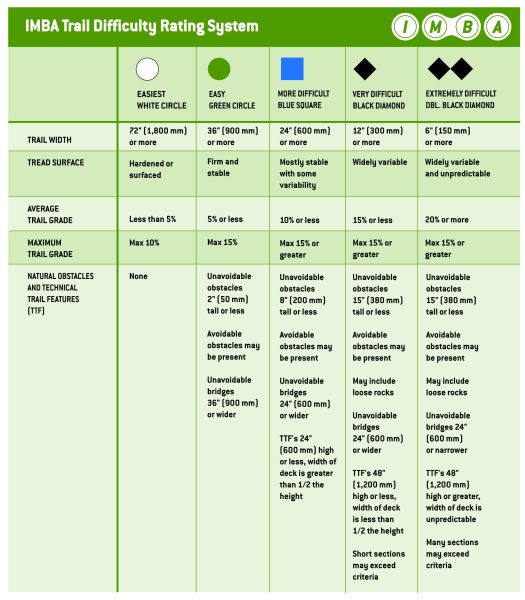
For IMBA, their classification applies to all trails, while for OSM it is reserved for bike parks. This is the key that defines the classification scheme that will be used to characterize the difficulty of the trails in the bike parks "BikePark". Suitable for mountain biking on trails with artificial obstacles.
Studying the IMBA classification criteria is enough to understand the OSM recommendation, this classification is difficult to apply to wildlife trails. Let's just take an example of the “Bridges” criterion, which does seem to be fully applicable to artificial bike park paths.