How to record clean GPS tracks?
If you've ever looked closely at your GPS, you must have seen that it's cluttered with configuration settings. You might also be surprised when you first tried to view on the map the last track recorded by all generated “unstable” points.
Strange, strange. Did you say strange?
Well, that's not all that strange, but suddenly it says a lot about GPS's ability to accurately reproduce reality.
In fact, with GPS, which allows us to set the data logging frequency, we will have the intuition to pick the fastest sample. We tell ourselves: the more points, the better!
But is it really a good choice to get a trail as close to reality as possible? 🤔
Let's take a closer look, it's a little technical (no integrals, don't worry ...), and we'll be with you.
Influence of the margin of error
In the digital world, the concept of quantification always has a more or less vague impact.
Ironically, what may seem like a better choice, namely using a higher recording rate for track points, can be counterproductive.
Definition: FIX is the ability of GPS to calculate position (latitude, longitude, altitude) from satellites.
[Posting Across the Atlantic After the Measurement Campaign] (https://www.tandfonline.com/doi/pdf/10.1080/13658816.2015.1086924) states that under the most favorable reception conditions it is an azure blue. sky 🌞 and GPS positioned in the horizon 360 ° field of view, ** FIX accuracy is 3,35 m 95% of the time**
⚠️ Specifically, with 100 consecutive FIXes, your GPS geolocates you between 0 and 3,35m from your real location 95 times and 5 times outside.
Vertically, the error is considered to be 1,5 times greater than the horizontal error, so in 95 cases out of 100 the recorded height will be +/- 5 m from the actual height under conditions of optimal reception, which is often difficult near the ground.
In addition, various publications available show that reception from multiple constellations 🛰 (GPS + GLONASS + Galileo) does not improve the horizontal GPS accuracy.
On the other hand, a GPS receiver capable of interpreting the signal of several constellations of satellites will have the following improvements:
- Reducing the duration of the first FIX, because the more satellites there are, the larger their receiver will be once it is launched,
- improving the accuracy of positioning in difficult reception conditions. This is the case in the city (urban canyons), at the bottom of a valley in mountainous areas or in a forest.
You can try it with your GPS: the result is clear and finished.
The GPS chip sets FIX every second altogether.
Almost all cycling or outdoor GPS systems allow you to adjust the frequency of these FIXs to track (GPX). Either they are all recorded, the selection is 1 time per second, or the GPS takes 1 out of N (for example, every 3 seconds), or the tuning is done from a distance.
Each FIX is to determine the position (latitude, longitude, altitude, speed); the distance between two FIXes is obtained by calculating the arc of a circle (located on the circumference of the globe 🌎) that passes through two successive FIXes. The total running distance is the sum of these distance intervals.
Basically, all GPS do this calculation to get the distance traveled without taking into account the altitude, then they integrate the correction to account for the altitude. A similar calculation is made for the height.
So: the more FIX there is, the more the record follows the actual path, but the more the horizontal and vertical position error part will be integrated.
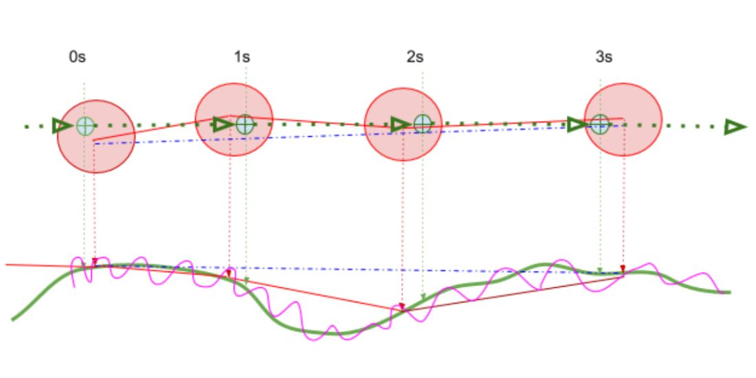
Illustration: in green is the real path in a straight line to simplify reasoning, in red is the GPS FIX at 1 Hz with position uncertainty materialized around each FIX: the real position is always in this circle, but not centered. , and in blue is the translation to GPX if it is done every 3 seconds. Purple indicates the altitude error measured by the GPS ([see this tutorial to fix it] (/blog/altitude-gps-strava-inaccurate).
The position uncertainty is less than 4 m 95% of the time under ideal reception conditions. The first implication is that between two successive FIXs, if the offset is less than the position uncertainty, the offset recorded by that FIX contains a large proportion of that uncertainty: it is measurement noise.
For example, at a speed of 20 km / h, you move 5,5 meters every second; although everything is perfect, your GPS can measure an offset of 5,5m +/- Xm, the X value will be between 0 and 4m (for a 4m position uncertainty), so it will place this new FIX with a position between 1,5m and 9,5 m from the previous one. In the worst case, the error in calculating this sample of the traveled distance can reach +/- 70%, while the GPS performance class is excellent!
You have probably already noticed that at a constant speed on the plain and in good weather, the points of your track are not evenly spaced: the lower the speed, the more they diverge. At 100 km/h, the impact of the error is reduced by 60%, and at 4 km/h, the speed of a pedestrian reaches 400%, it is enough to observe the tourist's GPX track, only to see that it is always very “intricate”.
Consequently :
- the higher the recording rate,
- and the lower the speed,
- the more the distance and height of each fix will be erroneous.
By recording all CORRECTIONS into your GPX, within one hour or 3600 records you have accumulated 3600 times the horizontal and vertical GPS error, for example, by decreasing the frequency by 3 times. be over 1200 times.
👉 One more point: the vertical GPS accuracy is not high, too high recording frequency will increase this gap 😬.
As the speed increases, gradually the distance traveled between two successive FIX becomes predominant in relation to the position uncertainty. The cumulative distances and heights between all consecutive FIXs recorded on your track, that is, the total distance and vertical profile of that course, will be less and less affected by location uncertainty.
How can these unwanted effects be counteracted?
Let's start by defining the speed classes for mobility:
- 🚶🚶♀Group hikes, the average speed is low, about 3-4 km / h or 1 m / s.
- 🚶 In sport travel mode, the average speed class is 5 to 7 km / h, that is, about 2 m / s.
- 🏃 In Trail or Running modes, the normal speed class is between 7 and 15 km / h, that is about 3 m / s.
- 🚵 On a mountain bike, we can take an average speed of 12 to 20 km / h, or about 4 m / s.
- 🚲 When driving on the road, the speed is higher from 5 to 12 m / s.
That hiking therefore, it is necessary to assign a recording in increments of 10 to 15 m, the GPS inaccuracy error will only be taken into account 300 times per hour (approximately) instead of 3600, and the effect of the position error, which increases from a maximum of 4 m per 1 m to a maximum of 4 m per 15 m, will be reduced 16 times. The track will be much smoother and cleaner, and the measurement noise is taken into account. divided by the factor 200! The tip every 10-15 m will not erase the restoration of the pins in the laces, it will just be a little more segmented and less noisy.
That trails Assuming an average speed of 11 km / h, recording with a time step that changes from 1 every second to 1 every 5 seconds reduces the number of recordings from 3600 to 720 per hour, and the maximum (possible) error is 4 m every 3 m. Becomes 4 m every 15 m (i.e. from 130% to 25%!). The error accounting by the recorded trace is reduced by about 25 times. The only drawback is that paths at risk of severe curvature are slightly segmented. « Risk "**, because although this is a trail, the speed on the curves will inevitably drop, and therefore two consecutive FIX will come closer, which will weaken the segmentation effect.
mountain biking is at the junction between low speeds (<20 km/h) and medium speeds (> 20 km/h), in the case of a track with a slow profile to very (<15 km/h) slow – the frequency is 5 s. is a good compromise (including Trail), if it's an XC type profile (>15 km/h), keeping 3s seems like a good compromise. For a higher speed (DH) usage profile, select one or two seconds as the write speed.
For a speed of 15 km / h, the choice of the track recording frequency from 1 to 3 s reduces the GPS error accounting by about 10 times. Since, in principle, the turning radius is related to speed, accurate trajectory recovery in narrow hairpins or turns will not be compromised.
Conclusion
The latest versions of GPS available for outdoor activities and cycling provide the location accuracy seen in the study cited at the beginning of the article.
By optimizing the recording rate to your average driving speed, you will significantly reduce the distance and height error of your GPX track: your track will be smoother and will hold well on tracks.
The demonstration is based on ideal reception conditions when these reception conditions deteriorate 🌧 (clouds, canopy, valley, city). The position uncertainty increases rapidly, and the unwanted effects of a high FIX recording rate at a low speed will be amplified.
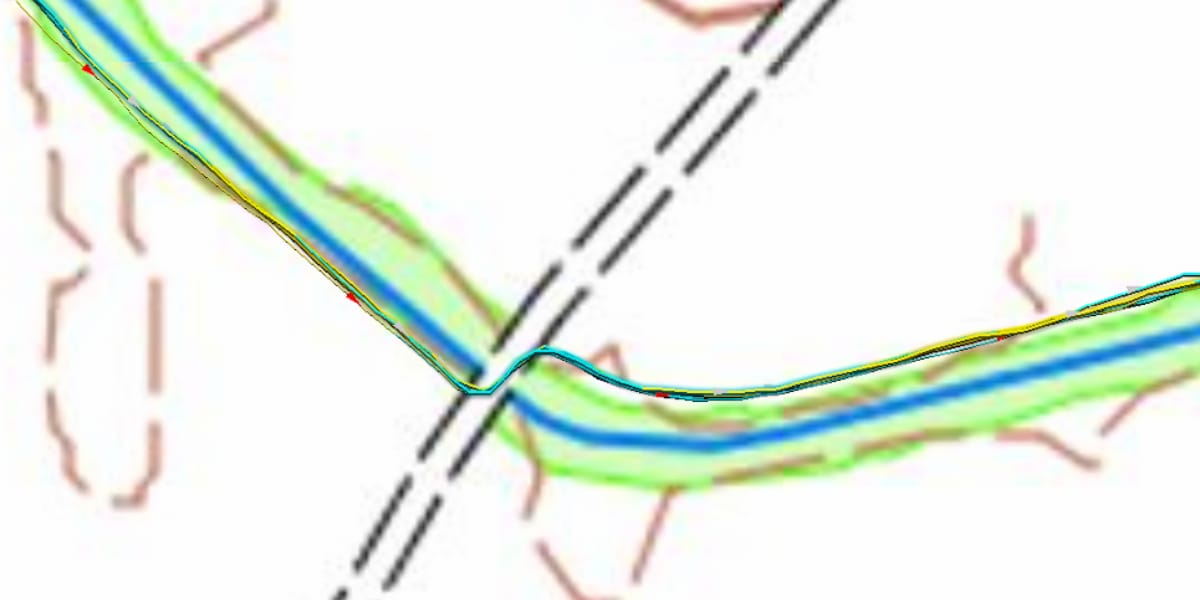
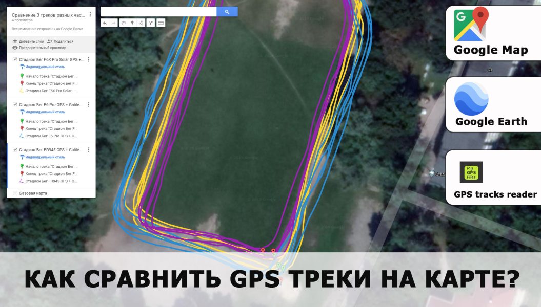
The image above shows a bayonet passing through an open field without a mask to observe only the effect of the FIX transmission frequency in the GPX file.
These are four tracks recorded during a trail (running) training session at a speed of 10 km / h. They were randomly selected throughout the year. Three records (traces) are loaded by FIX every 3 seconds and one FIX every 5 seconds.
First observation: the recovery of the trajectory during the passage of the bayonet does not deteriorate, which had to be demonstrated. Second observation: all observed "small" lateral deviations are present on the "selected" paths after 3 seconds. The same observation is obtained when comparing the traces recorded at frequencies of 1 s and 5 s (for this speed range), the track plotted with FIX spaced 5 seconds apart (for this speed range) is cleaner, the total distance and altitude will be closer. to the real value.
Therefore, on a mountain bike, the GPS position recording rate will be set between 2 s (DH) and 5 s (ride).
📸 ASO / Aurélien VIALATTE – Cristian Casal / TWS