Mountain biking navigation: track, road or RoadBook?
Content
We often hear complaints from mountain bikers “We drive with GPS or a smartphone app, but most of the time we skip intersections, especially downhill ...”
What if we fix the problem once and for all?
Following the track (GPS file) requires constant attention, especially in a group, during the adrenaline pumping phases or on the descent, where it's so good to get carried away!
The mind is fascinated by piloting or the landscape and cannot fleetingly direct its gaze to the screen, not forgetting that sometimes in technical transitions the terrain does not allow this or physical fatigue (being in the red zone) no longer allows it. !
The job of your GPS navigation software or your application is to detect intersections in order to warn you of their proximity.
For cyclists, this problem is easily solved when the software calculates a route in real time on a vector map, like the GPS of a car does on paved roads.
Off-road, on trails, when guidance consists of following a GPX track, the GPS software or app can only detect turns. However, each turn does not necessarily correspond to a change in direction. Conversely, any change in direction does not mean a turn.
Take, for example, climbing the Alpe d'Huez, where there are about thirty hairpins and five forks. What is useful information? Is there information on each stud or just in front of each fork?
To understand this difficulty, there are solutions:
- Integrate real-time "routing" into the built-in navigation software in your GPS or app.
- It is also necessary that the cartography is correctly informed, which is not yet relevant at the time of this writing. This will probably be possible in a few years. In doing so, unlike a car, the user does not necessarily look for the shortest or fastest route, but takes into account the fun and technical aspect of the route.
- The solution, now built into Garmin, is causing controversy in the forums that spark this thread.
Sound guidance, but if it has to play an audible message in each cord of an individual element, this sound guidance loses all interest.
Replace “track to follow” with ROUTE “to follow” or RoadBook “to follow” by inserting “decision points” or waypoints (WPt).
- Near these WPt your GPS or app will alert you without looking at the screen.
- Between the two WPTs, your GPS synthetically represents the next decision you need to make and the next one that allows you to remember it and act reflexively, without having to regularly or constantly look at the screen.
It's pretty easy to create a RoadBook, just add an icon at the intersections by dragging and dropping it using the dedicated software.
Road construction is not very difficult, all you have to do is create a track by placing only the points located at the intersection, then add an icon (as for the RoadBook) and define the proximity distance.
Unlike using tracing, especially in the case of import via the Internet, preparatory work is necessary, which will take a little time and may seem tedious..
Another point of view will be that, like the "elite", you prepare (at least partially) your exit, you will foresee the main difficulties, and, above all, you will avoid all the "galleys" of localization, requiring to set foot on land or "gardening", according to course You will fully enjoy the track, your mountain bike, GPS or app will become real partners!
The time that is considered "LONG" during preparation turns out to be the "WIN" time capital in the field ...
This article uses Land software and a proprietary GPS navigator TwoNav as an example.
Typical track following problem.
The illustration above uses the ".gpx" trace loaded on UtagawaVTT. The track is then imported into the Komoot Route Planner to identify the main “hard points”. and ... Bingo! the parcel is shown with dotted lines because Open Street Map does not know the path or paths below the track at this point!
Of two things:
- Or is it confidential singleso don't walk in front of the front door without noticing it, which would be a shame!
- Either the matter is in the error of the surrendered path, a common thing, and further 300 m will need to be developed!
Chance "Frog" in this place is important as well as “I don’t see the recording of this single”given that the site is at the top of a 15% hill, the mind will be less alert and more focused on managing the "recovery" effort!
In the following image, the Land software "confirms" with the IGN map and OrthoPhoto that there is no known footprint at this location. The entrance is at the end of the 15% rise, it is more than likely that those who will be in the "red" will not notice the entrance of this single (there the smoothing of the track goes towards the secret single). )!
Therefore, the beep emitted by the GPS will be welcomed to encourage people to look left in search of a secret passage!
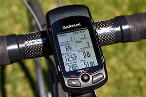
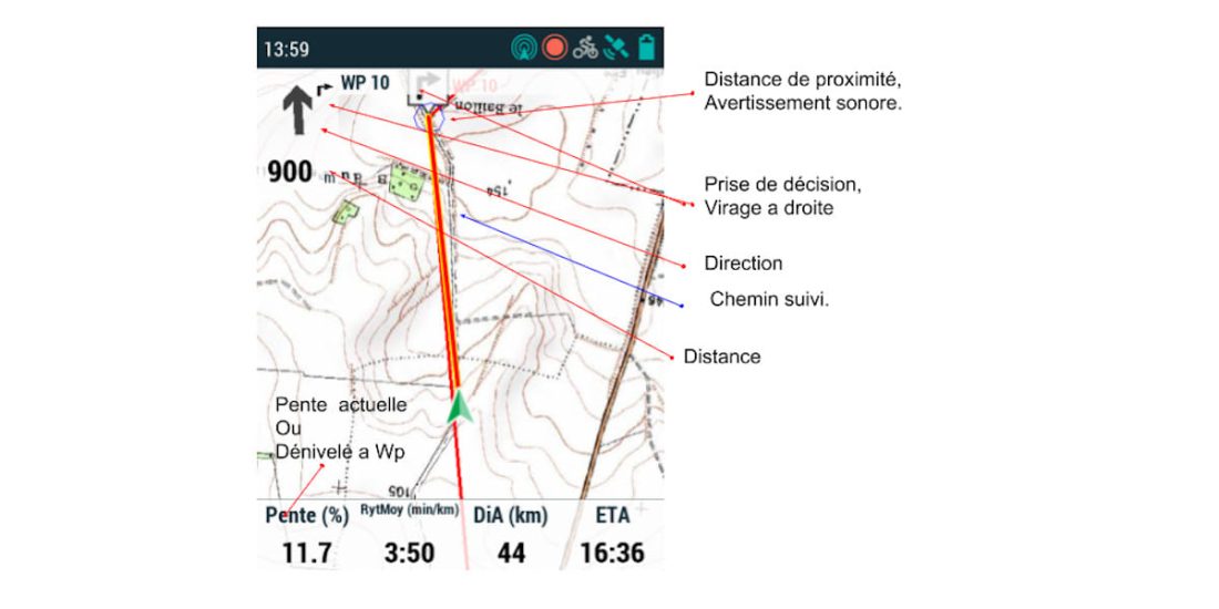
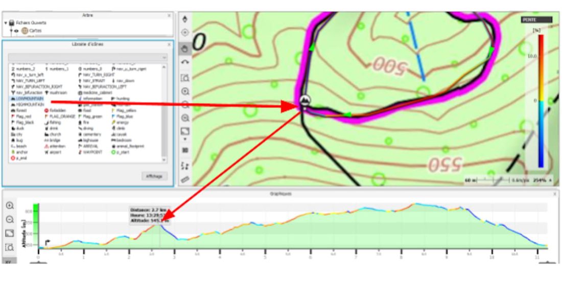
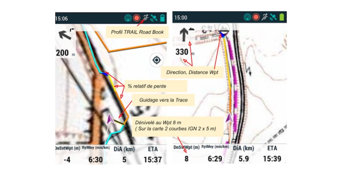
The image below shows the tracking instructions, the data displayed is by arrival or by snapshot. In RoadBook or Route mode, you can view data related to the next waypoint (summit, hazard, intersection, point of interest, etc.).
Develop a ROUTE
Following the route is exactly like riding a mountain bike, but we are sure that the arrows are not on the ground at the intersection, they are on the GPS screen, so they can be seen long before they are at the intersection!.
Prepare a route
A route is just a track (GPS file) simplified by reducing the number of waypoints on the track to what is needed.
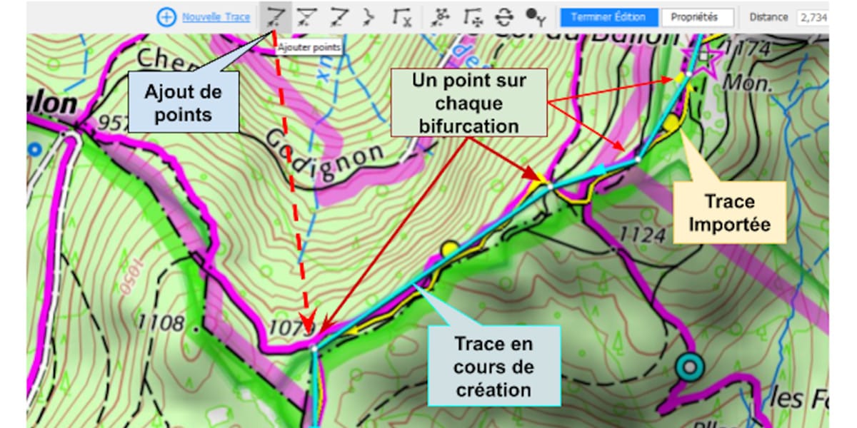
In the figure below, the alignment consists only of points located at each important fork, the connection between the two points is a simple straight line.
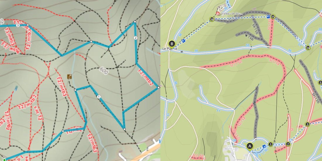
The concept is this: when the “rider” is on a track or single track, he can only drive out at intersections (as if he were in a pipe!). Thus, it is not necessary to have an exact route between two intersections.
Moreover, more often than not, this path is inaccurate, either due to natural changes or due to inaccurate GPS, or the map software (or file storage on the Internet) will limit the number of points (segmentation). your GPS (recently acquired more accurate) will place you on the map next to the trail and your track will be correct.
This track can be created by most apps, just uncheck "follow", in the previous image on the left is a track obtained with the OpenTraveller app, on the right is a track from Komoot, in both cases the background mapping is an MTB "layer" taken from Open Street Map with another view selected or created by the application.
Another method is to import a track (GPX) and then remove waypoints, but this is longer and more tedious.
Or it is enough to draw a simplified diagram "on top" of the imported alignment, this is a relatively simple and quick solution.
Land / Online Files / UtagawaVTT /it gets serious… .. (This is the name of the deposited track!)
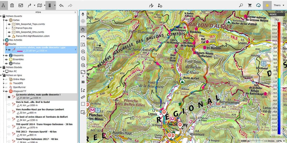
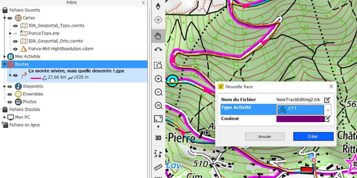
Right click on route / create new track
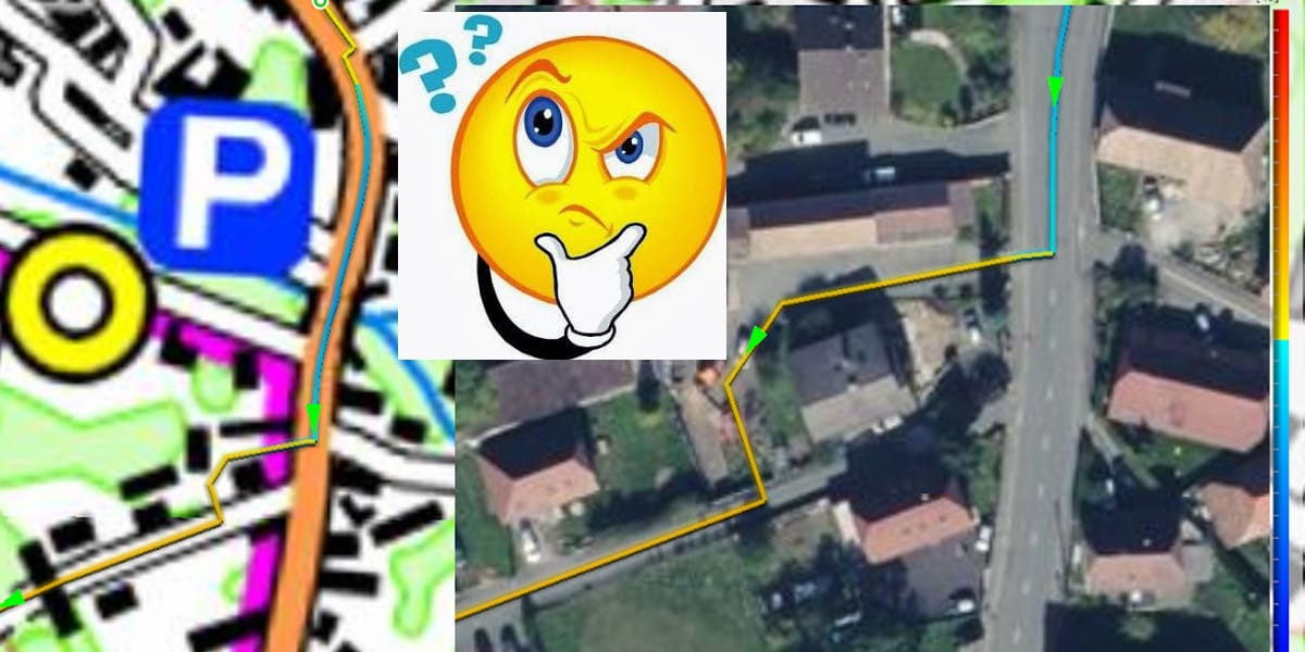
If the track is placed on terrain visible from the sky, the OrthoPhoto background overlay allows each bifurcation to be placed in its true location.
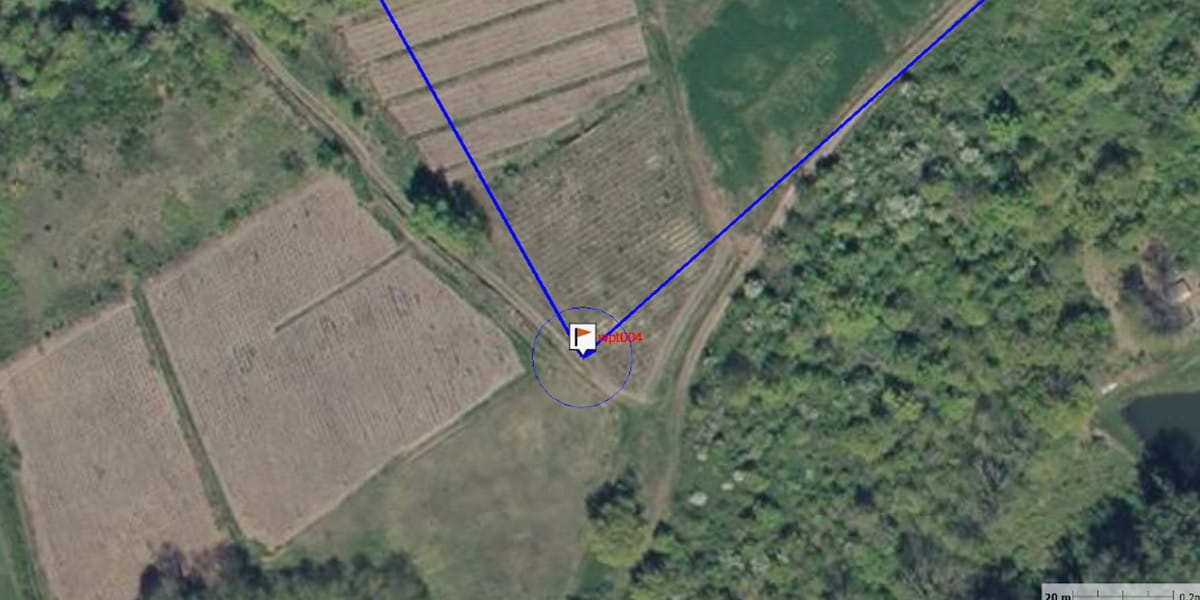
The image below (located in Beaujolais) illustrates the displacement of one WPt (18m), a displacement that is commonly observed. This shift is due to inaccuracies in the positioning of the OSM map data, likely due to mapping from older and less accurate GPS.
The IGN aerial photo is very accurate, WPt 04 needs to be moved to the intersection.
The Earth allows you to have a map, IGN Geoportal, OrthoPhoto, cadastre, OSM in the database.
Observed shifts in track positioning due to inaccuracies in maps, GPS, etc. tend to decrease, the latest GPS data is more accurate and the map frame (datum) has been moved to the same frame as the GPS (WGS 84) ...
Tip: After placing all the points, right-click the track to open the icon library tab.
This "trick" opens a tab with a list of available icons.
Two windows are open, you have to close the one that closes the map and leave one integrated in the left pane (icons).
Turning a track into a route
On a track in the ground: right click / list of points
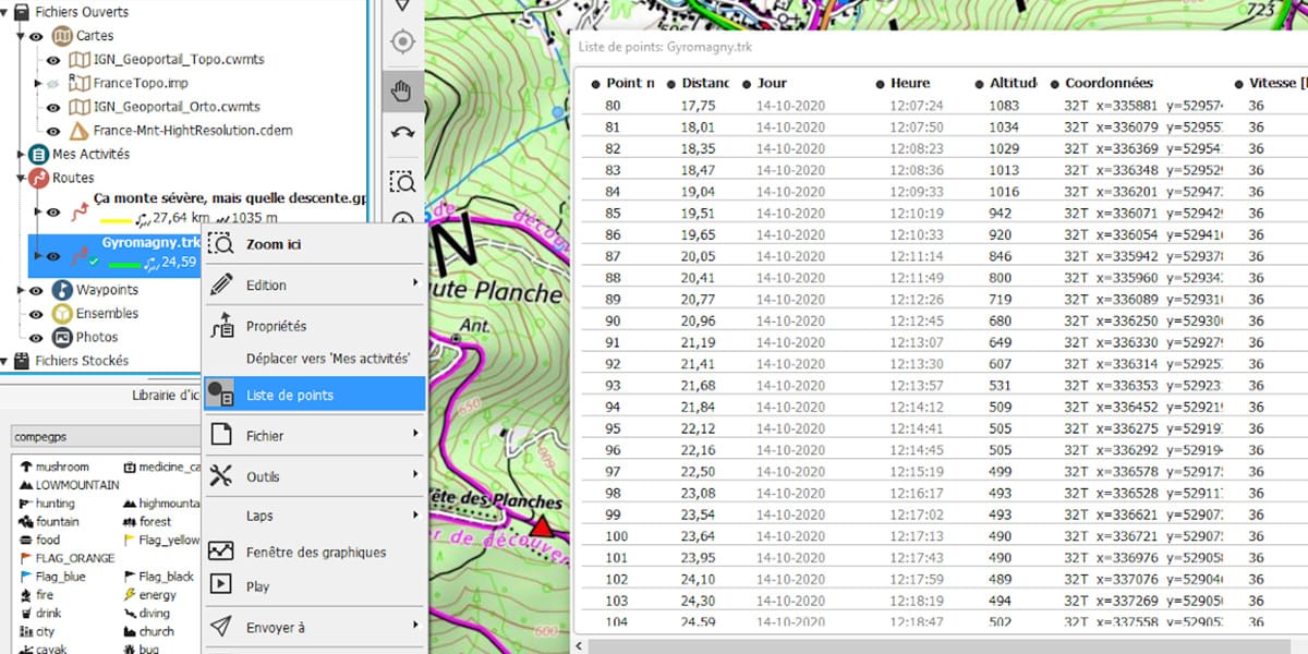
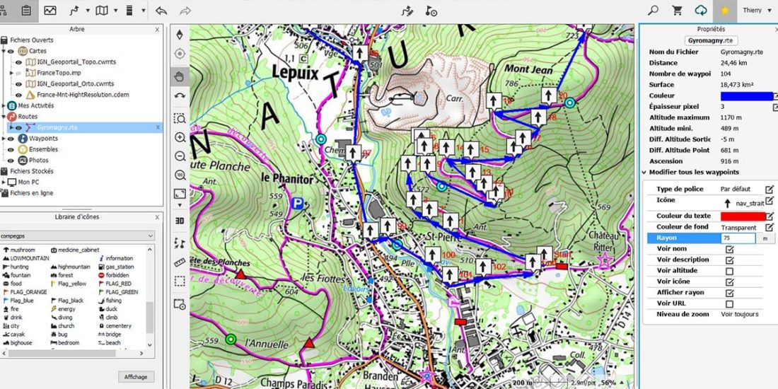
This track has (104 +1) 105 points, for example, the track from the router has a few hundred points, and the track from the GPS has several thousand.
Right click on the trail: tools / Convert Trk to RTE
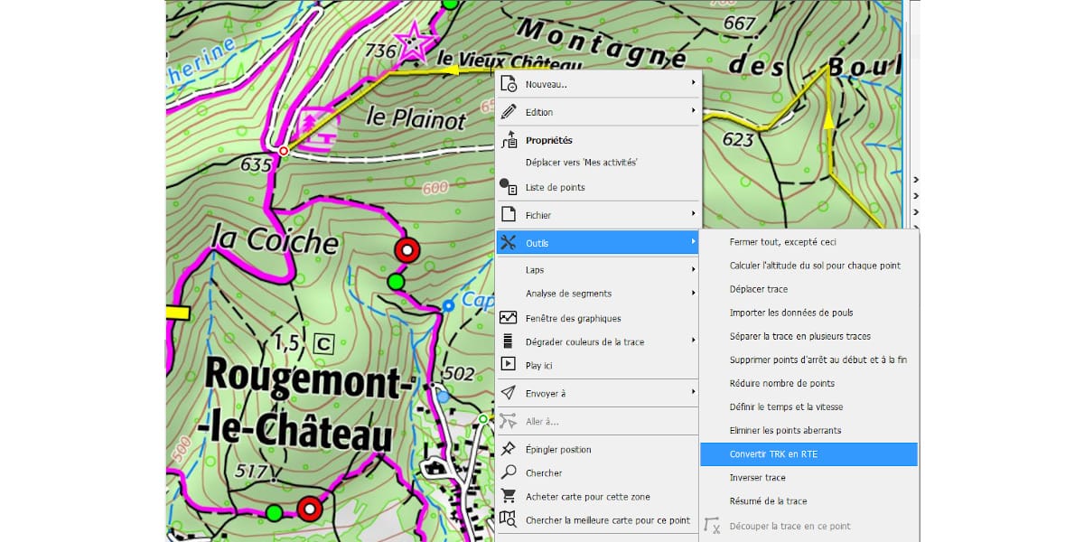
Enter the number of WPts, which in this tutorial's example is 105.
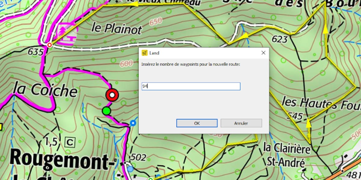
Land will create a new route file (.rte), by right clicking on it, you can view its properties.
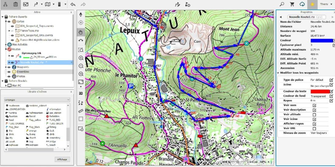
You can rename the new route (.rte) by right-clicking the name in the properties tab and close the original track.
Then save it to CompeGps / data so that it can be streamed to GO cloud.
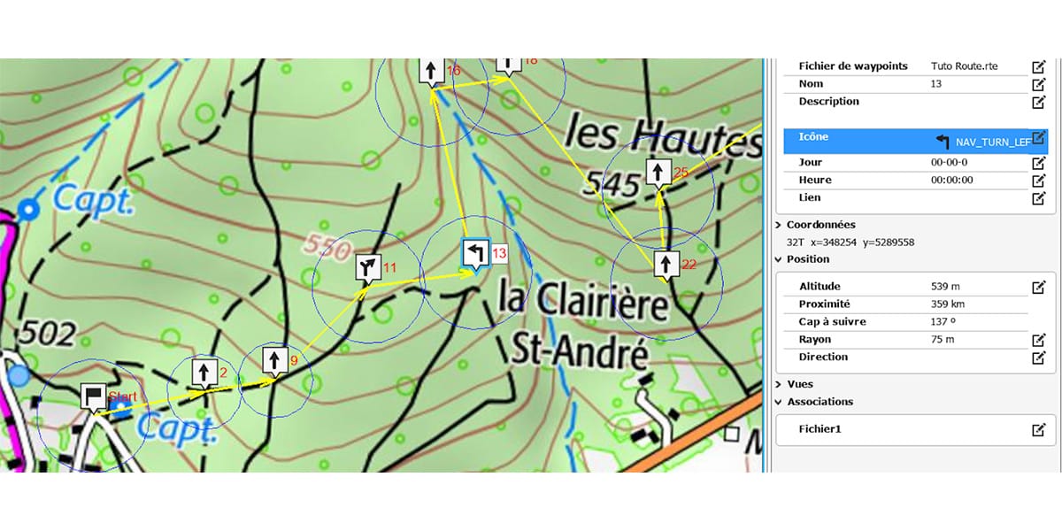
Then, on the properties tab, click the icon to assign the icon to all waypoints. «Nav_strait (RIGHT ON THE COURSE).
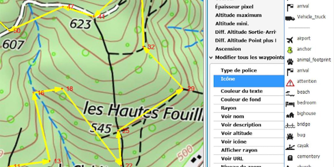
Right click Radius: enter 75m.
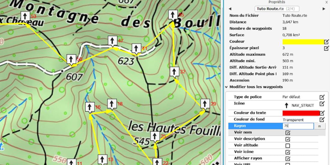
We assigned the default icon "nav_strait" and the view distance 75m.
If this route is exported as it appears on your GPS, 75 m upstream of each WayPoint, your GPS will beep to alert you to a Go Straight event.
A warning time of about 20 seconds before the intersection seems to be correct for forecasting and response, that is, on the order of 30 to 200 meters, depending on the nature of the terrain.
Due to uncertainty in the position of the GPS used to record the track, or inaccurate readings, if the track is the result of routing in the app, the intersection can be placed +/- 15m from its actual position. By adjusting the bifurcations in Land either on the orthophoto or on the IGN GéoPortail, this error is reduced to +/- 5 m.
The next step is to configure all the waypoints in turn, hence the need for consistent choices for the overall setup.
Two methods:
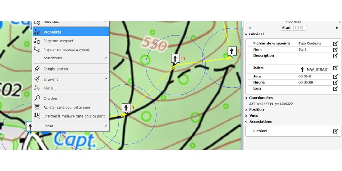
- Right clicking on each WayPoint opens or refreshes the properties tab for that Wpt.
- Dragging the icon with the mouse
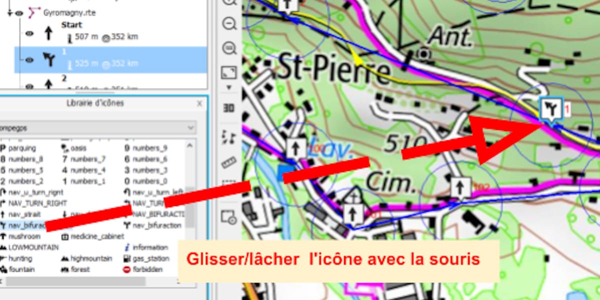
You can change the data. For icons, simply select an image that summarizes the decision, straight, fork, sharp bend, pin, etc. ...
For the radius, enter the desired waiting distance.
Example on WPt 11, this is a "right fork", WPt is placed on the well-known fork of the OSM map (current case also with a .gpx file), on the other hand, on the IGN map this fork is 45m upstream. If you follow the GPX directions, there is a high risk of going forward without turning off the road! The aerial view could be a judge of the peace, but in this case it is a dense forest under the canopy, the visibility of the sky is zero.
Due to the cartographic methodology of OSM versus IGN, it is highly likely that the correct bifurcation is observed on the IGN map.
In the illustrated case, following the ROUTE, the GPS will beep before reaching the intersection indicated on the IGN map, as the guide recommends follow up, the pilot will turn to the first track, "Bingo won" in some or real OSM or IGN bifurcation position.
When following the track, GPS recommends staying on the track, but if the fork is actually 45m off the ground, it is skipped on the ground, you will need to follow its tracks after you have been to see further ... but how far?
Another interest in following the route, you can add to your route, during its creation or later, by adding WayPoints: high points (climbs), low points, danger zones, wonderful places, etc., that is, any point that may require special attention. or action to make a decision.
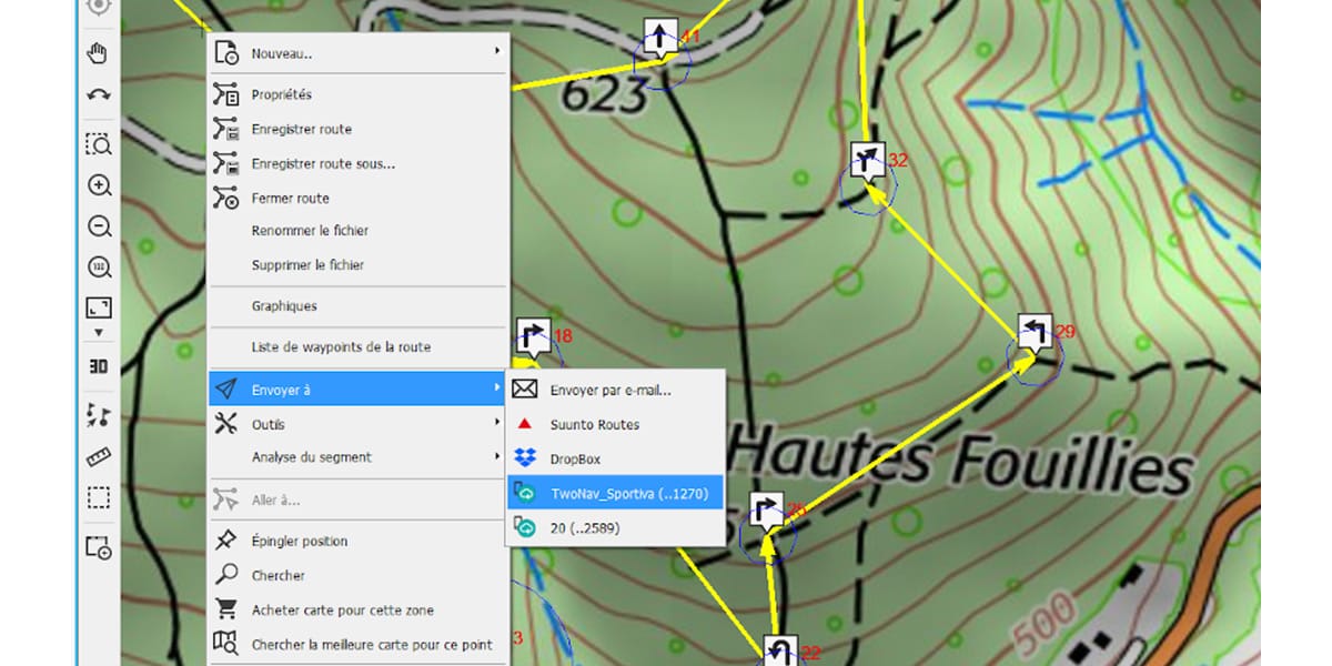
After completing this setup, all you have to do is record the route in order to send it to the GPS.
Follow the route using GPS
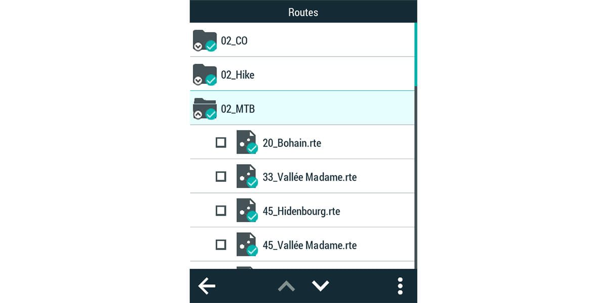
In GO cloud * .rte files invisiblehowever you will find them in your GPS route list.
The GPS configuration step is necessary to optimize GPS performance, this configuration can be saved in the MTB RTE profile, for example for future use. (only basic configuration items are listed here).
Configuration / Activity Profile / Alarms / Proximity to Waypoints /
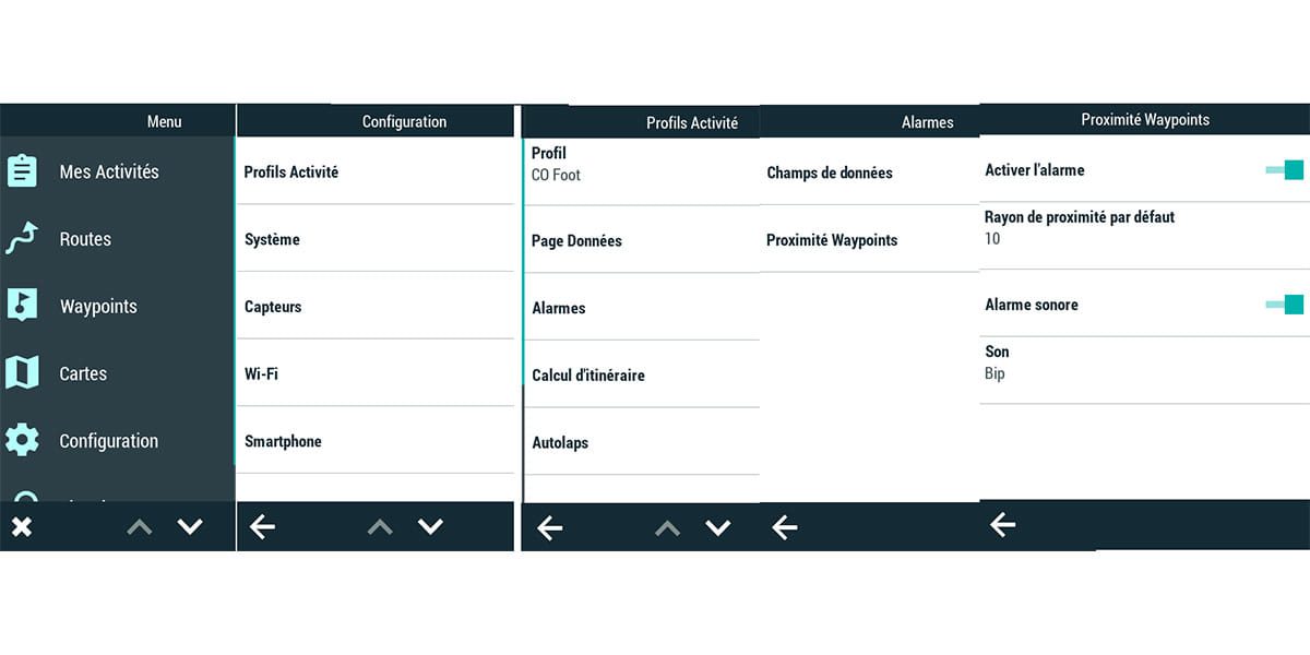
The proximity radius value defined here will be used if omitted or used in RoadBook tracking.
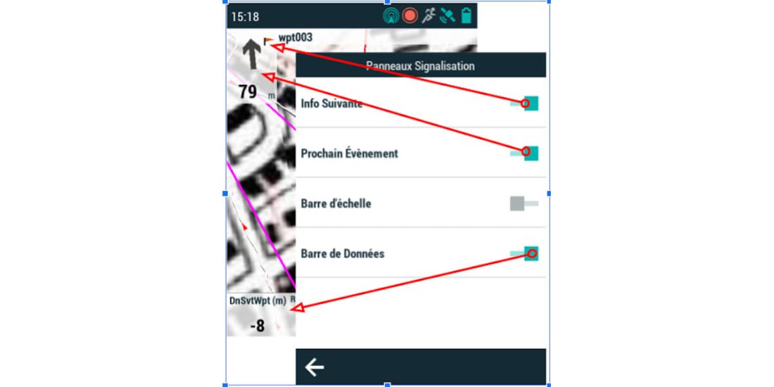
Configuration / Profile Activity / Map View / Traffic Signs
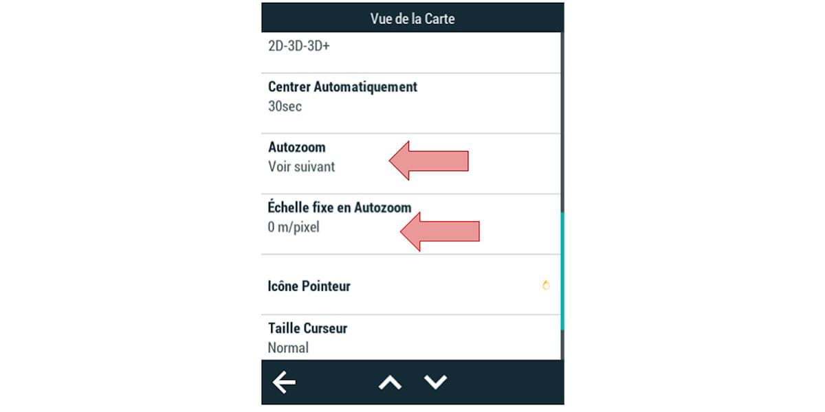
Configuration / Profile Activity / Map View
This setting adjusts the automatic zoom control, which is especially useful while driving.
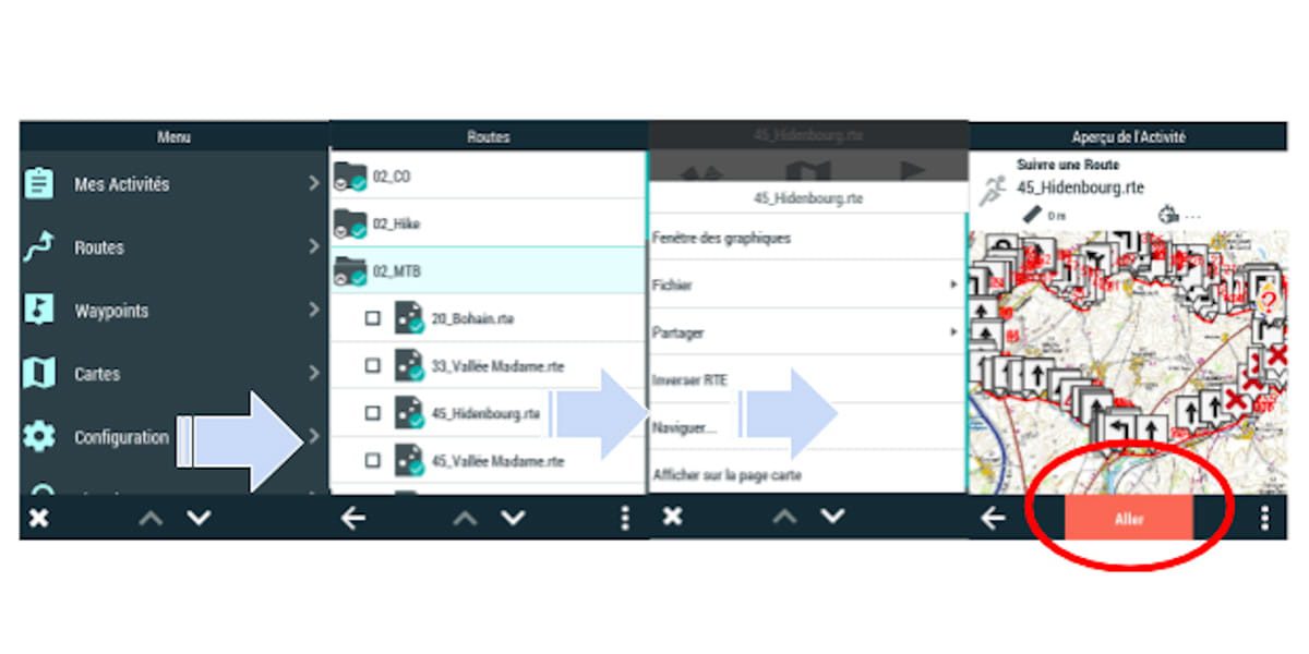
Starting a follow is identical to starting a track, just select a route and then GO.
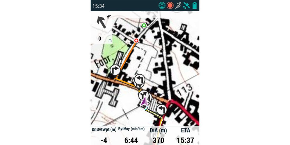
When tracking a track, your GPS guides you to keep or get you back on track, when tracking a route, it provides directions to reach the next WayPoint, so you must place WayPoints at the entrance of each branch ("pipe") of the route. , and note that in a branch / path ("pipe") you cannot get out of it, there is no need to look at the screen. The rider pays attention to piloting or terrain: he uses his mountain bike without leaving his GPS!
In the above example, when the "pilot" is on the track, he has synthetic information until the next change of direction, with "BEEP" it will be necessary to turn right, and the turn will be "marked as marked", it is necessary to plan d 'to adapt your speed, One glance at the screen, when attention allows, is enough to remember the next decision that needs to be made..
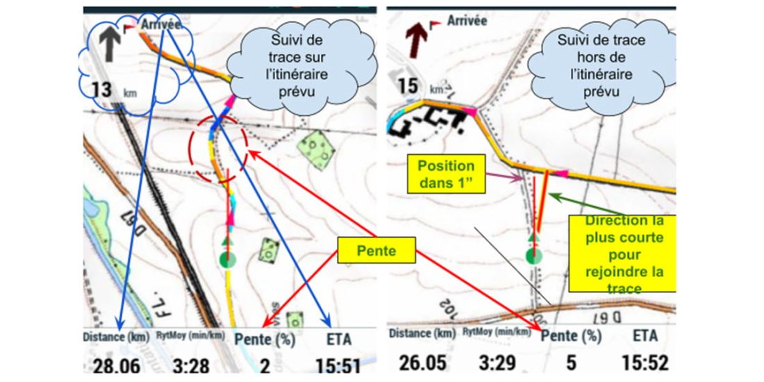
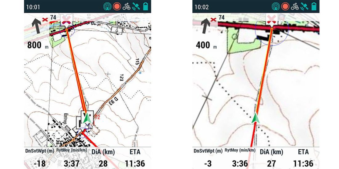
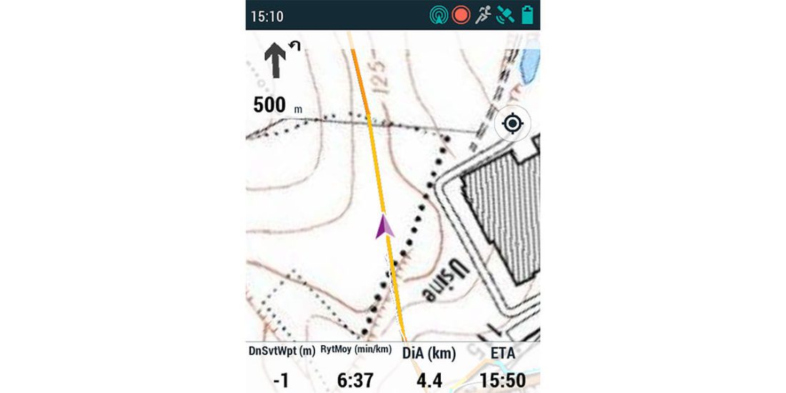
The two images below show another particularly clever aspect of route-following mode. "Auto Zoom" the first image shows the situation from 800 m and the second one from 380 m, the map scale has been automatically zoomed in. This feature is especially useful for moving around difficult areas without having to touch the zoom buttons or the screen.
Setting up the GPS MTB route tracking profile correctly eliminates the need to touch buttons while riding. GPS becomes a partner, it controls itself on the way.
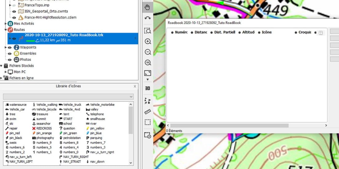
Create a RoadBook
The RoadBook is an interesting compromise for those who want to reassure themselves, that is, to be able to visually observe how "following the trail." GPS guidance provides indication of distance, altitude, and next decision; to the next waypoint while maintaining route navigation in case of deviation.
On the other hand, the expected view is reduced due to the loss of automatic scaling, it is necessary to determine the scale of the map, adapted to the practice of mountain biking, and sometimes resort to the zoom button.
RoadBook is a track enriched with waypoints. The user can associate data with each waypoint (icon, thumbnail, text, photo, internet link, etc.).
In normal mountain biking practice, in order to facilitate and enrich track following, the only need is a badge that gives a synthetic vision of the next decision to be made.
To illustrate the RoadBook's design, the user can either import a finished track (for example, direct import from Land from UtagawaVTT) or create their own track.
The image below shows a view of the route on two different cartographic backgrounds, and also indicates the nature of the paths along which it is necessary to go.
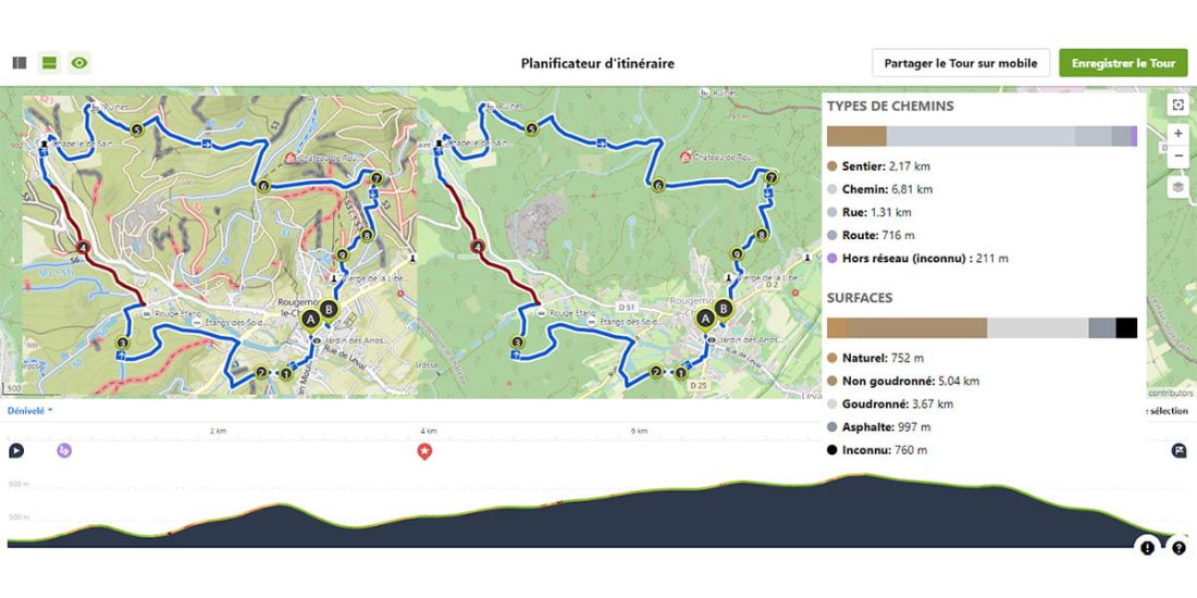
Route routing is faster and more efficient with an app (in this case Komoot) than with Land. After creation, the track is exported in Gpx format, then imported into Land, in order to convert it to RoadBook, you need to start by saving in * .trk format.
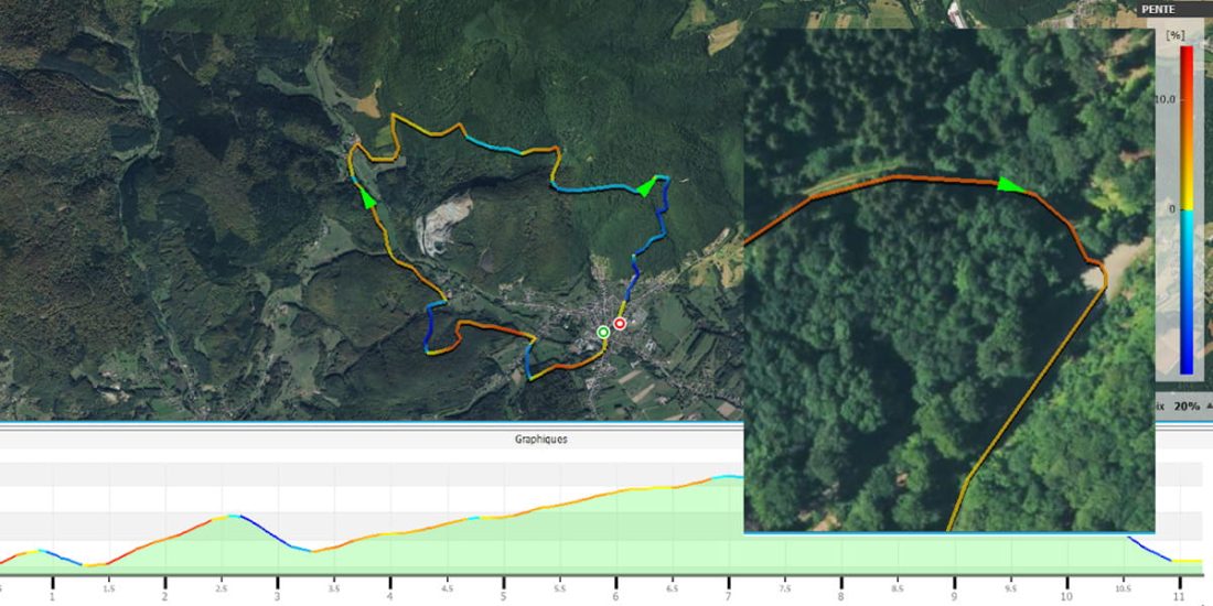
First added value of land it is a colorization of the slope that will provide readable information throughout the entire route with an expectation of a level of commitment in the future.
Second added value of land make sure the branches are in the right places.
Land accepts a wide variety of basemaps.
OSM background selection is of little interest, errors will be masked. Opening the OrthoPhoto IGN background (online map) will allow you to quickly determine the track positioning accuracy with a simple zoom. The insert inserted into the image highlights the track deviation from the track by about 3 m, an error that will be drowned out by GPS accuracy and therefore invisible in the field.
This test is required for an imported trace., depending on the GPS used for recording the track and the choice of the algorithm to reduce the file size a fork on an imported road (GPX) can move several hundred meters.
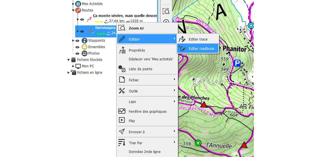
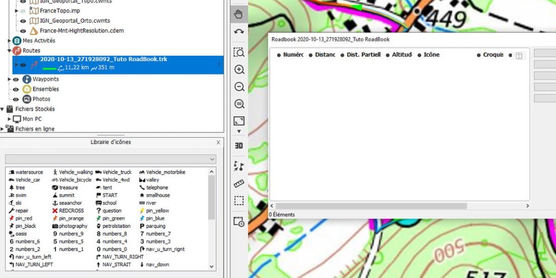
The next step is to edit the RoadBook. Right click on track / edit / edit RoadBook
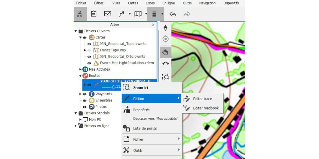
There are two windows open, you have to close the one that closes the map and leave one integrated in the left pane.
The first bifurcation emphasizes the problem of tracking the raw trace, here the routing corresponds to the OSM map data, in the case of an imported file, the same error will be observed either due to switching to private, or due to decreasing the track point, etc. Specifically, your GPS or your application asks you to turn before an intersection.
Click on the pencil at the top of the map to enter edit mode to move, delete, add points.
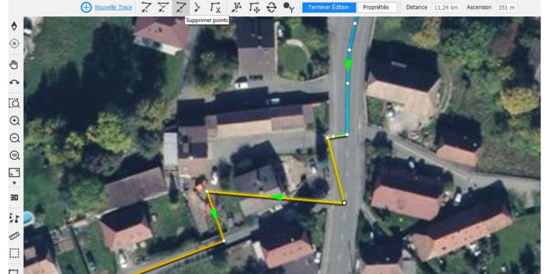
Our track is being corrected, all you have to do is drag the "sharp turn" icon to the right at the intersection.
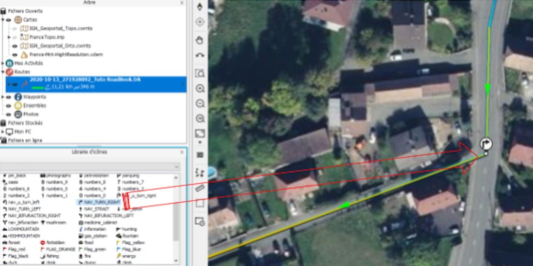
All decision points will need to be enriched with an icon that you just need to drag, it's pretty fast. The following illustration highlights the richness and interest of the process, in addition to correcting progress errors. Here the “top” icon is replaced with a turn icon, a “attention” or “red cross” icon can be placed for danger. If configured for this purpose, the GPS will be able to indicate the remaining grade or elevation to climb, which is especially useful for managing your efforts.
When the enrichment is complete, all you have to do is save the file in .trk format and send the track to GPS, since for the route the .trk or .gpx files are visible in the GO CLOUD.
GPS setting
GPS tuning step is necessary to optimize GPS performance, this configuration can be saved in the MTB RoadBook profile, for example, for future use (only basic configuration items are listed here).
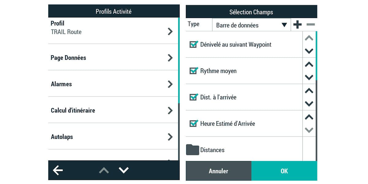
Configuration / Profile Activity / Page Defined
This page allows you to select the data displayed at the bottom of the map (data pane) as well as the data presented in the data pages. It is “smart” to optimize the data at the bottom of the map according to your usage to avoid having to touch the GPS while driving.
Configuration / Activity Profile / Alarms / Proximity to Waypoints /
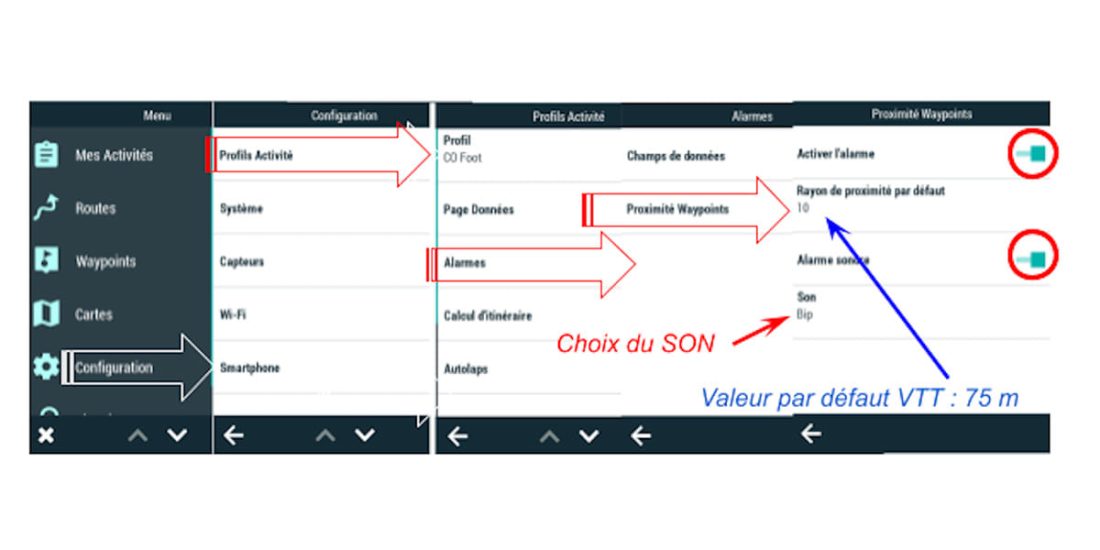
In RoadBook monitoring, the criterion of proximity to WayPoint is common to all WayPoints, you will have to find a compromise.
Configuration / Profile Activity / Map View / Traffic Signs

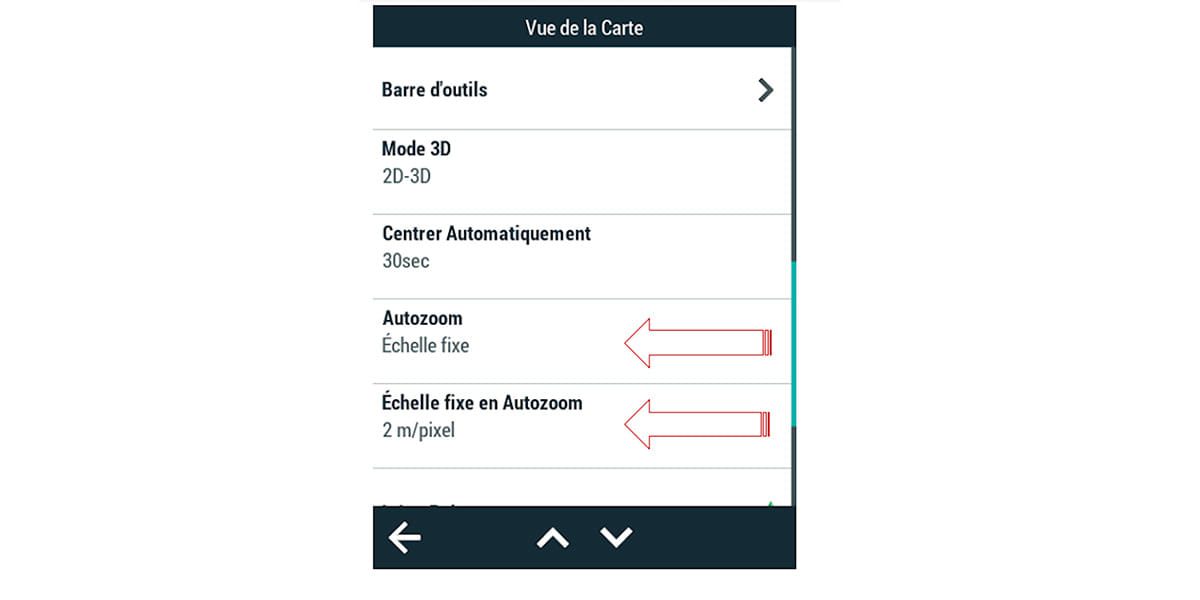
Configuration / Profile Activity / Map View
Auto Zoom Control is disabled in RoadBook Tracking, you need to set the default zoom to 1/15 or 000/1, available directly from the menu.
Starting a continuation is identical to starting a track or route.
Track your RoadBook with GPS
When tracking the RoadBook, your GPS manual guides you to keep or get you back on track and gives directions to reach the next WayPoint, so you must place WayPoints at the entrance to each branch ("pipe") of the route, and note that in the branch / path ("Pipe") you cannot get out of it, so there is no need to constantly look at the screen. The rider pays attention to piloting or terrain: he takes advantage of his mountain bike, regardless of the GPS-assisted "head"!
In the above example (on the left), "pilot" has synthetic information to join the track and navigate until the next change of direction, with "BEEP" you have to select the next one marked on the right, in the image 'on the right, by a beep, it will peak. One glance at the screen, when attention allows, is enough to remember the next decision that needs to be made..
Compared to following a route in RoadBook mode, the See. The next one does not work, in a difficult situation you will have to zoom in manually, as shown in the picture below.
On the other hand, if the path does not exist on the map, it materializes as a track.
Criterias of choice
| Criterias of choice | ||||
| Route (* .rte) | road book | Trace | ||
| Design | Ease | ✓ | 🇧🇷 | 🇧🇷 |
| Import | ✗ | ✗ | ✓ ✓ ✓ ✓ ✓ | |
| Training | ✓ | 🇧🇷 | 🇧🇷 | |
| Circles | Lightness / smoothness | ✓ | ✓ | ✓ |
| Expectation | ✓ ✓ ✓ ✓ ✓ | 🇧🇷 | ✓ | |
| Interaction (*) | ✓ ✓ ✓ ✓ ✓ | 🇧🇷 | ✓ | |
| Risk of losing surveillance | 🇧🇷 | ✓ | ✗ | |
| Focus of attention | Paths | Paths | GPS | |
(*) Be on the route, position, level of commitment, difficulty, etc.